Woonsocket (Rhode Island)
- Woonsocket (Rhode Island)
-
42° 00′ 06″ N 71° 30′ 26″ W / 42.001667, -71.507222
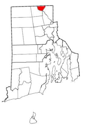
Woonsocket est une ville américaine située dans le comté de Providence, dans l’État du Rhode Island. En 2005, sa population s’élevait à 44 328 habitants. Densité: 939,3 hab./km² (2 433,9 hab./mi²). Superficie totale : 20,6 km² (8 mi²). Coordonnées géographiques : 42°0′6″N 71°30′26″O / 42.00167, -71.50722.
Histoire
La ville compte une importante communauté d’origine québécoise. En effet, au début du XXe siècle, de nombreux Québécois ont fui la misère de leur région d’origine pour travailler dans les manufactures américaines, principalement des tissages, établies après la Première Guerre mondiale, avec l’aide d’ingénieurs français, tel Auguste Dupire, envoyés de Roubaix, ville manufacturière du nord de la France.
Source
Wikimedia Foundation.
2010.
Contenu soumis à la licence CC-BY-SA. Source : Article Woonsocket (Rhode Island) de Wikipédia en français (auteurs)
Regardez d'autres dictionnaires:
Woonsocket (Rhode Island) — Woonsocket Rathaus Lage in Rhode Island … Deutsch Wikipedia
Woonsocket (Rhode Island) — Woonsocket Ciudad de los Estados Unidos Centro de Woonsocket … Wikipedia Español
Woonsocket, Rhode Island — Infobox Settlement official name = City of Woonsocket settlement type = City imagesize = image caption = Downtown Woonsocket established title2 = Incorporated (city) established date2 = 1888 established title = Incorporated (town) established… … Wikipedia
Main Street Historic District (Woonsocket, Rhode Island) — Main Street Historic District U.S. National Register of Historic Places U.S. Historic district … Wikipedia
North End Historic District (Woonsocket, Rhode Island) — North End Historic District U.S. National Register of Historic Places U.S. Historic district … Wikipedia
St. Ann's Church Complex (Woonsocket, Rhode Island) — Infobox nrhp | name =St. Ann s Church Complex nrhp type = caption = location= Woonsocket, Rhode Island lat degrees = 42 lat minutes = 0 lat seconds = 27 lat direction = N long degrees = 71 long minutes = 30 long seconds = 8 long direction = W… … Wikipedia
South Main Street Historic District (Woonsocket, Rhode Island) — Infobox nrhp | name =South Main Street Historic District nrhp type = hd caption = location= Woonsocket, Rhode Island locmapin = Rhode Island area = architect= Multiple architecture= Greek Revival, Queen Anne, Other added = November 24, 1982… … Wikipedia
U.S. Post Office (Woonsocket, Rhode Island) — Infobox nrhp | name =U.S. Post Office nrhp type = caption = location= Woonsocket, Rhode Island lat degrees = 42 lat minutes = 0 lat seconds = 17 lat direction = N long degrees = 71 long minutes = 30 long seconds = 46 long direction = W locmapin … Wikipedia
Woonsocket Falls, Rhode Island — Woonsocket Falls Village was a village in Woonsocket, Rhode Island founded in the 1820s and taking up much of the area around Market Square. Entrepreneurs built many factories in the area which were powered by Blackstone River water flowing to… … Wikipedia
Rhode Island Route 114 — Infobox RI Route type= route=114 length mi=45.6 length km=73.4 formed=1923 dir1=South dir2=North from= junction= to= previous type= previous route=113 next type= next route=114A Route 114 is a numbered State Highway running 45.6 miles in the U.S … Wikipedia
 Pour les articles homonymes, voir Woonsocket.
 États-Unis
 Rhode Island