Visual Approach Chart
- Visual Approach Chart
-
Carte d'approche à vue

Pour les articles homonymes, voir
VAC.
Les cartes d'approche et d'atterrissage à vue (ou VAC : Visual Approach Chart) sont des documents émis en France par le SIA (Service d'information aéronautique).
Contenu
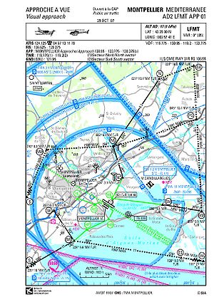
Les cartes VAC d'approche contiennent les informations suivantes :
- Le nom de l'aéroport, ainsi que son code OACI
- Les coordonnées terrestre de l'aéroport, ainsi que son altitude
- Les fréquences radio :
- d'approche
- de la tour
- du sol
- de l'ATIS
- de l'ADF et de l'ILS
- les différentes zones d'espace aérien entourant l'aéroport ainsi que les points de report radio éventuels
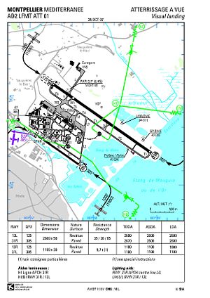
Les cartes d'atterrissage contiennent :
- Les pistes, en précisant :
- leurs longueurs
- leurs revêtements
- leurs résistances
- leurs aides lumineuses
- les obstacles et dangers à l'atterrissage
- un plan des installations au sol (tour de contrôle, parking, pompe à essence...)
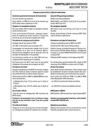
Les cartes peuvent aussi contenir une page d'informations particulières, qui regroupe tout ce qui ne peut pas être dit sur les autres pages (procédures particulières de décollage et/ou atterrissage...), ainsi que les informations secondaires (restaurants, taxis, aéro-club...).
Exemple de carte VAC : LFMT
Liens externes
 Portail de l’aéronautique
 Portail des transports
Catégorie : Réglementation aéronautique
Wikimedia Foundation.
2010.
Contenu soumis à la licence CC-BY-SA. Source : Article Visual Approach Chart de Wikipédia en français (auteurs)
Regardez d'autres dictionnaires:
charted visual approach — Approach in which a radar controlled aircraft on an IFR (instrument flight rules) flight plan (FP), operating in VFR (visual flight rules) conditions, and having an ATC (air traffic control) authorization may proceed to the airport of intended… … Aviation dictionary
approach chart — An aeronautical chart providing essential information for making an approach to an airfield under either visual or instrument flight conditions … Aviation dictionary
visual descent points — A point on the final approach course of a nonprecision straight in approach procedure from which normal descent from the minimum decision altitude (MDA) to the runway touchdown point may be commenced, provided the visual reference required is… … Aviation dictionary
Visual acuity — 20/15 and 20/15 vision redirect here. For other uses, see 2020 (disambiguation). Typical Snellen chart used for visual acuity testing. Visual acuity (VA) is acuteness or clearness of vision, which is dependent on the sharpness of the retinal… … Wikipedia
Instrument approach — Terminal procedures for an ILS approach in the United States. (The disclaimers shown in red in the illustration do not appear on the original approach plate.) For aircraft operating under instrument flight rules (IFR), an instrument approach or… … Wikipedia
State-Chart — Ein Zustandsübergangsdiagramm ist eine grafische Darstellung von endlichen Automaten, d. h. Zuständen und deren Übergangsbedingungen, um die enthaltenen Verknüpfungen möglichst durchschaubar und eindeutig zu visualisieren. Anwendung findet das… … Deutsch Wikipedia
Snellen chart — A Snellen chart is an eye chart used by eye care professionals and others to measure visual acuity. Snellen charts are named after the Dutch ophthalmologist Herman Snellen who developed the chart in 1862.DescriptionThe traditional Snellen chart… … Wikipedia
Terminal area chart — In United States and Canadian aviation, Terminal area charts are aeronautical charts intended for navigation under Visual Flight Rules that depict areas surrounding major airports (primarily those with Class B airspace.OverviewLike the VFR… … Wikipedia
aeronautical chart — A chart prepared and issued primarily for air navigation. The chart shows selected terrain, cultural, and hydrographic features and supplemental information required for air navigating, piloting, or planning air operations. It contains all or… … Aviation dictionary
charted visual flight procedures — Charted visual approaches established at locations with jet operations for noise abatement purposes. The approach charts depict prominent landmarks, courses, and recommended altitudes to specified runways. These procedures are used only in radar… … Aviation dictionary