Stompetoren
Contenu soumis à la licence CC-BY-SA. Source : Article Stompetoren de Wikipédia en français (auteurs)
Regardez d'autres dictionnaires:
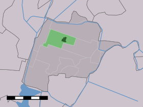
Stompetoren — Dutch town locator maps mun town caption = The town centre (dark green) and the statistical district (light green) of Stompetoren in the municipality of Schermer.Stompetoren (coord|52|37|N|4|49|E|type:city(1087)) is a town in the Dutch province… … Wikipedia
List of windmills in Noord Holland — A list of windmills in the Dutch province of Noord Holland.{| class= wikitable ! Location! Name of mill! Type! Built! Notes! Photograph Aalsmeer De Leeuw Stellingmolen 1863 [http://www.molendatabase.nl/nederland/molen.php?nummer=621… … Wikipedia
Schermer (Gemeinde) — Gemeinde Schermer Flagge Wappen Provinz Nordholland Bürgermeister … Deutsch Wikipedia
Schermer — Infobox Settlement official name = Schermer mapsize = 280px flag size = 150x75px image shield = Schermer wapen.png shield size = 150x75px subdivision type = Country subdivision name = Netherlands subdivision type1 = Province subdivision name1 =… … Wikipedia
Pieter Post — Huis ten Bosch, La Haye Pieter Jansz Post (1608, Haarlem 1669, La Haye) est un architecte, peintre et imprimeur néerlandais du siècle d or néerlandais. Sommaire … Wikipédia en Français
Kinderdijk — Coordinates: 51°53′N 4°38′E / 51.883°N 4.633°E / 51.883; 4.633 … Wikipedia
List of places in the Netherlands — This is an alphabetical list of places (cities, towns, villages) in the Netherlands. Lists per province can be found at:* List of towns in Groningen * List of towns in Friesland * List of towns in Drente * List of towns in Overijssel * List of… … Wikipedia
De Adriaan, Haarlem — Windmill De Adriaan De Adriaan is a windmill in the Netherlands that burnt down in 1932 and was rebuilt in 2002. The original windmill dates from 1779 and the mill has been a distinctive part of the skyline of Haarlem for centuries. Contents … Wikipedia
Pieter Post — Pieter Jansz Post (baptised May 1 1608, Haarlem ndash; buried May 8 1669, The Hague) was a Dutch architect, painter and printmaker. Post was the son of a stained glass painter and the older brother of painter Frans Post. [cite web| title=The… … Wikipedia
Driehuizen (Schermer) — 52°34′44″N 4°48′32″E / 52.57889, 4.80889 … Wikipédia en Français
 Pays-Bas