Sahand
- Sahand
-
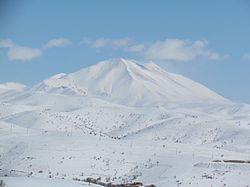
Le Sahand (en persan سهند) est le plus haut sommet de la province d'Azerbaïdjan oriental en Iran.
C'est une des plus hautes montagnes de l'Azerbaïdjan iranien et c'est aussi un volcan inactif important dans le pays. Le Sahand est situé au sud de Tabriz et son plus haut pic est le Jam Daqi avec une altitude de 3 707 m. On peut compter environ 17 pics de plus de 3 000 mètres dans cette montagne.
Sur le Sahand se trouve la station de sports d'hiver de Sahand.
Sahand est aussi le nom d'une frégate iranienne de Classe Saam, coulée lors de l'opération Praying Mantis par les forces américaines en 1988.

Image satellite du Sahand.
Liens externes
Sur les autres projets Wikimedia :
Wikimedia Foundation.
2010.
Contenu soumis à la licence CC-BY-SA. Source : Article Sahand de Wikipédia en français (auteurs)
Regardez d'autres dictionnaires:
Sahand — Kuh e Sahand Höhe 3.710 m Lage Iran … Deutsch Wikipedia
Sahand — For the Iranian Frigate Sahand see: Iranian frigate Sahand. Infobox Mountain Name = Sahand Photo = SahandNASA.jpg Caption = NASA Space Shuttle image of Sahand. NW at top. Elevation = Convert|3707|m|ft|0|abbr=on Location = East Azarbaijan, Iran… … Wikipedia
Sahand University of Technology — Infobox University copy; Sahand University of Technology name=Sahand University of Technology native name=دانشگاه صنعتي سهند established=1989 type=Public city=Tabriz state=East Azarbaijan country=Iran president = Mohammad Reza Chenaghlou… … Wikipedia
Sahand Airport — Infobox Airport name = Sahand Airport nativename = nativename a = nativename r = image width = caption = IATA = ACP ICAO = OITM type = owner = operator = city served = location = Maragheh, Iran elevation f = 4396 elevation m = 1340 coordinates =… … Wikipedia
Station de sports d'hiver de Sahand — Sahand Kuh e Sahand Vue satellite du Kuh e Sahand. Géographie Altitude 3 707 m Massif … Wikipédia en Français
Kuh-e Sahand — Höhe 3.710 m … Deutsch Wikipedia
Iranian frigate Sahand — (in Persian سهند), a British made Vosper Mark V class frigate (also known as Alvand class frigate), was commissioned as part of a four ship order. The ship was originally called Faramarz , named after a character in Ferdosi s Shahnameh. However… … Wikipedia
Operation Praying Mantis — Part of Iran Iraq War Iranian frigate IS Sahand (74) attacked by aircraft … Wikipedia
Azar-Shahr — Maragha DEC … Deutsch Wikipedia
Gonbad-e-Kabud — Maragha DEC … Deutsch Wikipedia
 Iran
Iran