Roosendaal
- Roosendaal
-
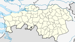
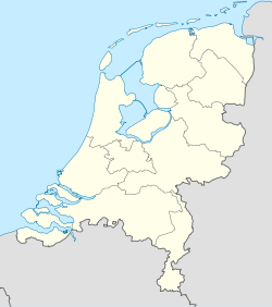
Roosendaal est une commune et une ville des Pays-Bas de la province du Brabant-Septentrional.
Histoire de la commune
La commune actuelle de Roosendaal a été créée le 1er janvier 1997 par la fusion des communes de Roosendaal en Nispen et Wouw. Elle fut connue pendant de nombreuses années (comme sa voisine Bergen-Op-Zoom) comme une source d'approvisionnement en cannabis de nombreux consommateurs de cannabis Belges et Français jusqu'à la décision de fermeture des coffee shops par les autorité municipales à la fin 2008.
Localités
Lien externe
Wikimedia Foundation.
2010.
Contenu soumis à la licence CC-BY-SA. Source : Article Roosendaal de Wikipédia en français (auteurs)
Regardez d'autres dictionnaires:
Roosendaal — Roosendaal, s. Rozendal … Pierer's Universal-Lexikon
Roosendaal — (Rozendaal), Flecken in der niederländ. Provinz Nordbrabant, Knotenpunkt der Eisenbahnen nach Antwerpen, Vlissingen, Moerdijk, Rotterdam und Breda, mit reformierter und kath. Kirche, Zollamt, Schiffswerften, Zuckerfabriken, Mühlen, Vieh und… … Meyers Großes Konversations-Lexikon
Roosendaal — Roosendaal, niederländ. Flecken, s.v.w. Rozendaal (s.d.) … Kleines Konversations-Lexikon
Roosendaal — Infobox Settlement official name = Roosendaal mapsize = 280px subdivision type = Country subdivision name = Netherlands subdivision type1 = Province subdivision name1 = North Brabant area footnotes = (2006) area total km2 = 107.21 area land km2 … Wikipedia
Roosendaal — Gemeinde Roosendaal Flagge Wappen Provinz … Deutsch Wikipedia
Roosendaal — ▪ municipality, The Netherlands in full Roosendaal En Nispen, gemeente (municipality), southwestern Netherlands (Netherlands, The), near the Belgian border. Roosendaal (“Valley of Roses”) developed after the inhabitants of surrounding… … Universalium
Roosendaal — Original name in latin Roosendaal Name in other language Roosendaal, Rozendal , ZYO, Розендаль State code NL Continent/City Europe/Amsterdam longitude 51.53083 latitude 4.46528 altitude 4 Population 77725 Date 2010 01 29 … Cities with a population over 1000 database
Roosendaal — Sp Ròzendalis Ap Roosendaal L Nyderlandai … Pasaulio vietovardžiai. Internetinė duomenų bazė
Roosendaal en Nispen — Ancienne commune des Pays Bas Histoire Administration Pays Pays … Wikipédia en Français
Roosendaal en Nispen — was a municipality in the Dutch province of North Brabant. It included the villages of Roosendaal and Nispen.In 1997, the municipality merged with Wouw. As the town of Roosendaal had become by far the largest in the new municipality, the name of… … Wikipedia

 Pays-Bas