Pervomaïskyï
- Pervomaïskyï
-
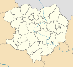
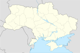
Pervomaïskyï (en ukrainien : Первомайський) ou Pervomaïski (en russe : Первомайский) est une ville de l'oblast de Kharkiv, en Ukraine, et le centre administratif du raïon de Pervomaïskyï. Sa population s'élevait à 30 842 habitants en 2011.
Géographie
Pervomaïskyï est située à 67 km au sud de Kharkiv.
Histoire
En 1869, est mise en service la ligne de chemin de fer Koursk – Kharkiv – Sebastopol. Un arrêt pour l'approvisionnement des locomotives en charbon et en eau est établi dans un village nommé Lykhatchove (en ukrainien : Лихачове). Un château d'eau est construit. L'agriculture demeure l'activité essentielle du village. En 1929, lorsque commence la collectivisation de l'agriculture, un station de machines et de tracteurs (SMT) est créée à Lykhatchove. Pendant la Seconde Guerre mondiale, le village est occupé par l'Allemagne nazie le 20 octobre 1941 et libéré le 16 septembre 1943 par le Front de la steppe de l'Armée rouge.
Le 24 juin 1952, le village est rebaptisé Pervomaïskyï, qui devient le centre administratif d'un raïon en 1965. L'importante usine chimique Khimprom est mise en service en 1968 au sud de l'agglomération, dont l'importance s'accroît alors rapidement et Pervomaïskyï reçoit le statut de ville en 1991.
Population
Recensements (*) ou estimations de la population [1] :
Évolution démographique
| 1970* |
1979* |
1989* |
2001* |
2008 |
2009 |
2010 |
2011 |
| 15 666 |
31 141 |
37 474 |
32 523 |
31 001 |
30 883 |
30 910 |
30 842 |
Notes et références
- ↑ (en) World Gazetteer [1] — (uk) Comité d'État de statistiques d'Ukraine : Статистичний збірник «Чисельність наявного населення України на 1 січня 2008 року» [Manuel statistique « Nombre d'habitants de l'Ukraine au 1er janvier 2008 »]. [2] ; «Статистичний збірник "Чисельність наявного населення України на 1 січня 2010 року» [Manuel statistique « Nombre d'habitants de l'Ukraine au 1er janvier 2010 »]. [3]
Liens externes
|
|
| Villes |
Balakliia • Barvinkove • Bohodoukhiv • Derhatchi • Izioum • Kharkiv • Koupiansk • Krasnohrad • Lioubotyn • Lozova • Merefa • Pervomaïskyï • Pivdenne • Tchouhouïv • Valky • Vovtchansk • Zmiïv |
 |
| Communes urbaines |
Andriïvka • Babaï • Berezivka • Bezlioudivka • Bilyï Kolodiaz • Birky • Blyzniouky • Borova • Boudy • Charivka • Chevtchenkove • Dvoritchna • Eskhar • Houty • Kehytchivka • Khorocheve • Kivcharivka • Kolomak • Komsomolske • Korotytch • Kostiantynivka • Kotchetok • Koulynytchi • Koup'iansk-Vouzlovyï • Kov'iahy • Kozatcha Lopan • Krasnokoutsk • Krasnopavlivka • Mala Danylivka • Malynivka • Mantchenky • Nova Vodolaha • Novopokrovka • Orilka • Outkivka • Panioutyne • Peressitchna • Petchenihy • Pissotchny • Pokotylivka • Proudianka • Prykolotne • Rohan • Sakhnovchtchyna • Savyntsi • Slatyne • Solonytsivka • Staryï Mertchyk • Staryï Saltiv • Tchapaieve • Tchervonyï Donets • Tchkalovske • Vassychtcheve • Velykyï Bourlouk • Vilchany • Viltcha • Vvedenka • Vyssokyï • Zatchepylivka • Zidky • Zolotchiv |
Catégories :
- Ville d'Ukraine
- Ville de l'oblast de Kharkiv
Wikimedia Foundation.
2010.
Contenu soumis à la licence CC-BY-SA. Source : Article Pervomaïskyï de Wikipédia en français (auteurs)
Regardez d'autres dictionnaires:
Pervomaiskyi — ( uk. Первомайський) is a city in Kharkiv Oblast (province) of Ukraine. Population is 32,523 (2001)and 41,352 (Current figures by the city administration).The city is known for its popular Khimprom which was one of the biggest chemical factories… … Wikipedia
Kharkiv — For other uses, see Kharkiv (disambiguation). Kharkov redirects here. For other uses, see Kharkov (disambiguation). Kharkiv (Харків) Kharkov (Харьков) Freedom Square, Kharkiv … Wikipedia
Chuhuiv — Coordinates: 49°50′8″N 36°41′11″E / 49.83556°N 36.68639°E / 49.83556; 36.68639 … Wikipedia
Derhachi — For the town in Russia, see Dergachi, Russia. Derhachi (Ukrainian: Дергачі, Russian: Дeргaчи, translit. Dergachi) is a city in the Kharkiv Oblast (province) of eastern Ukraine. It is the administrative center of the Derhachivskyi Raion (district) … Wikipedia
Merefa — coat of arms Merefa (Ukrainian: Мeрeфa) is a city in eastern Ukraine. It is located in the Kharkivsky Raion (district) of the Kharkiv Oblast (province). The current estimated population is around 23,679 (as of 2005) … Wikipedia
List of raions in Ukraine by subdivision — Below is the list of all raions in Ukraine, listed by subdivisions of which they are a part. Contents 1 Autonomous Republic of Crimea 2 Cherkasy Oblast 3 Chernihiv Oblast 4 … Wikipedia
Pervomaisk, Mykolaiv Oblast — Pervomaisk (Ukrainian: Первомайськ Pervomajs k) is a city in Mykolaiv Oblast, Ukraine and the center of the Pervomaiskyi Raion. It is located on the Southern Bug river which bisects the city. Its population in 2001[update] was 70,170. The name… … Wikipedia
Kharkiv Oblast — Infobox Ukrainian oblast Name = Kharkiv Oblast UkrainianName = Харківська область TransliteratedName = Kharkivs’ka oblast’ Nickname = Харківщинаspaces|2(Ukrainian) Kharkivshchyna spaces|2(transliteration) Ukraine Administrative center = Kharkiv… … Wikipedia
Mykolaiv Oblast — Миколаївська область Mykolayivs’ka oblast’ Oblast … Wikipedia
Mykolaiv — This article is about the shipbuilding port in southern Ukraine. For the smaller town in Lviv Oblast of Ukraine, see Mykolaiv, Lviv Oblast. For other uses, see Nikolayev. Coordinates: 46°58′N 32°0′E / … Wikipedia


 Ukraine
 Oblast de Kharkiv
 30 842 hab. (2011)


