Paragould (Arkansas)
- Paragould (Arkansas)
-
Paragould
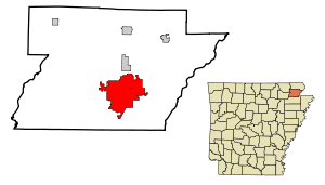
La ville de Paragould est le siège du comté de Greene, dans l’État de l’Arkansas, aux États-Unis. Selon le recensement de 2006, sa population s’élève à 23 775 habitants. Densité : 122,7 hab./km² (317,7 hab./mi²). Superficie totale : 80,2 km² (31 mi²). Coordonnées géographiques : 36°3′25″N 90°30′11″O / 36.05694, -90.50306.
Histoire
Le nom de la ville regroupe les noms de J. W. Paramore et Jason Gould, propriétaires de deux lignes de chemin de fer qui se croisaient à cet endroit. Paragould a été incorporée le 3 mars 1883. Son nom s’est également écrit Para-Gould et ParaGould.
Lien externe
Source
- (en) Cet article est partiellement ou en totalité issu d’une traduction de l’article de Wikipédia en anglais intitulé « Paragould, Arkansas ».
 Portail des États-Unis
Catégories : Ville de l'Arkansas | Comté de Greene (Arkansas) | Siège de comté de l'Arkansas
Wikimedia Foundation.
2010.
Contenu soumis à la licence CC-BY-SA. Source : Article Paragould (Arkansas) de Wikipédia en français (auteurs)
Regardez d'autres dictionnaires:
Paragould, Arkansas — Infobox Settlement official name = Paragould, Arkansas settlement type = City imagesize = image caption = image imagesize = image caption = image mapsize = 250px map caption = Location in Greene County and the state of Arkansas mapsize1 = map… … Wikipedia
National Bank of Commerce Building (Paragould, Arkansas) — National Bank of Commerce Building U.S. National Register of Historic Places … Wikipedia
Arkansas State University Paragould — is an instructional site of the Arkansas State University System s flagship Jonesboro campus. The campus is located in Paragould, Arkansas. The Campus Arkansas State University Paragould s campus is housed in a former Wal Mart retail store near… … Wikipedia
Paragould High School — is a public school serving grades nine through twelve located in Paragould, Arkansas. The campus is located at 1701 West Court Street in Paragould and is administered by the Paragould School District.The school s mascot is the Ram. The Pargould… … Wikipedia
Paragould School District — is a public school district located in Paragould, Arkansas. The district includes numerous campuses, including the Paragould Secondary Complex (which includes Paragould High School and Paragould Junior High School), the Oak Grove Heights campus… … Wikipedia
Arkansas locations by per capita income — Arkansas is the forty eighth richest state in the United States of America, with a per capita income of $16,904 (2000). Arkansas Places Ranked by Per Capita Income # Morrison Bluff, Arkansas ndash; $56,436 # Prairie Creek, Arkansas ndash; $37,355 … Wikipedia
Paragould — 36° 03′ 25″ N 90° 30′ 11″ W / 36.056944, 90.503056 … Wikipédia en Français
Arkansas — This article is about the U.S. state of Arkansas. For the river, see Arkansas River. For other uses, see Arkansas (disambiguation). State of Arkansas … Wikipedia
Arkansas State University System — Infobox University © Arkansas State University System name=Arkansas State University System motto= Powering Minds established=1909 type=Public president=Les Wyatt city=Jonesboro state=Arkansas country=USA undergrad= 17,401 [… … Wikipedia
Arkansas Center for Space and Planetary Sciences — The Old Field House at the U of A. Established 2000 Type Research Director L … Wikipedia
 États-Unis
 Arkansas