Pamunkey River
- Pamunkey River
-
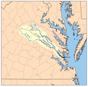
La Pamunkey River est une rivière tributaire de la York River, de 145 km de long dans l'est de l'État américain de Virginie. Via la York River, elle fait partie du bassin versant de la baie de Chesapeake.
Cours
La Pamunkey River est formée par la confluence de la North Anna River et de la South Anna River à la limite du comté de Hanover et du comté de Caroline à environ 8 km au nord-est de la ville d'Ashland. Elle coule principalement vers le sud-est, passe la Pamunkey Indian Reservation. Lors de la traversée de la ville de West Point, elle rencontre la Mattaponi River pour former la York River. La rivière forme en grande partie la limite sud des comtés de Caroline et de King William et la limite nord des comtés de Hanover et de New Kent.
Autres noms
Le Board on Geographic Names américain décida que "Pamunkey River" était le nom officiel en 1892 (nom d'origine algonquine). Selon le Geographic Names Information System, elle a aussi été connue sous les noms de :
- Pamauncke River
- Pamoeoncock River
- Pamunky River
- Pemaeoncock
- Yough-ta-mund
- Youghtanund
Références
Source
Wikimedia Foundation.
2010.
Contenu soumis à la licence CC-BY-SA. Source : Article Pamunkey River de Wikipédia en français (auteurs)
Regardez d'autres dictionnaires:
Pamunkey River — The Pamunkey River is a tributary of the York River, about 90 mi (145 km) long, in eastern Virginia in the United States. Via the York River it is part of the watershed of Chesapeake Bay.CourseThe Pamunkey River is formed by the confluence of the … Wikipedia
Pamunkey Regional Library — serves the counties of Goochland, Hanover, King and Queen, and King William, and the towns of Ashland and West Point in central Virginia. The service area is approximately 1,349 square miles with a population of about 128,000, of which… … Wikipedia
Pamunkey Indian Reservation — is a Native American Reservation located in Virginia in the United States. The reservation lies along the Pamunkey River in King William County, Virginia on the Middle Peninsula. The Pamunkey Indian Reservation contains approximately 1,200 acres… … Wikipedia
Pamunkey — The Pamunkey Native American tribe is one of two existing tribes in Virginia that were part of the Powhatan Confederacy. They inhabited the coastal tidewater of Virginia near Chesapeake Bay. The Pamunkey reservation is located on the site of some … Wikipedia
Pamunkey (Volk) — Verbreitung der Stämme in Virginia um 1610 Pamunkey heißt ein Indianerstamm im Nordosten der Vereinigten Staaten, der am gleichnamigen Fluss in Virginia lebte und dort noch heute ein Reservat besitzt, dessen Sprache jedoch nicht mehr gesprochen… … Deutsch Wikipedia
North Anna River — The North Anna River is a principal tributary of the Pamunkey River, about 62 miles (100 km) long,[1] in central Virginia in the United States. Via the Pamunkey and York rivers, it is part of the watershed of Chesapeake Bay. The river was… … Wikipedia
South Anna River — The South Anna River is a principal tributary of the Pamunkey River, about 85 mi (135 km) long, in central Virginia in the United States. Via the Pamunkey and York Rivers, it is part of the watershed of Chesapeake Bay.According to the Geographic… … Wikipedia
York River (Virginia) — York York River at Yorktown, ca. 1903 Name origin: York … Wikipedia
Chickahominy River — River Name origin: Chickahominy people Country … Wikipedia
York River State Park — is located near the unincorporated town of Croaker in James City County, Virginia on the south bank of the York River about 10 miles downstream from West Point. The York River is formed from the confluence of the Mattaponi River and the Pamunkey… … Wikipedia