Mbarara
- Mbarara
-
0° 39′ 00″ S 30° 41′ 00″ E / -0.65, 30.68333
Mbarara est une ville du Sud-Ouest de l'Ouganda, non loin de la frontière tanzanienne. Elle est située à 266 km de la capitale Kampala. C'est la capitale du district de Mbarara.
La ville compte environ 80 000 habitants. Elle est le siège de l'université de Mbarara, fondée en 1989.
Religion
Mbarara est le siège d'un archevêché catholique.
Wikimedia Foundation.
2010.
Contenu soumis à la licence CC-BY-SA. Source : Article Mbarara de Wikipédia en français (auteurs)
Regardez d'autres dictionnaires:
Mbarara — Land of Milk … Wikipedia
Mbarara — es una localidad del sudoeste de Uganda a unos 266 km de Kampala. Mbarara en el sudoeste de Uganda. Contenido 1 Contexto 2 Equi … Wikipedia Español
Mbarara — Mbarara, Stadt in Südwestuganda, 1 473 m über dem Meeresspiegel, 40 400 Einwohner; Verwaltungssitz des gleichnamigen Distrikts; katholischer Bischofssitz; Handelszentrum eines Landwirtschaftsgebiets, Holzverarbeitung. Geschichte: Früher… … Universal-Lexikon
Mbarara — Karte Lage von Mbarara innerhalb Ugandas Basisdaten Distrikt Mbarara Geographische Lage … Deutsch Wikipedia
Mbarara — Original name in latin Mbarara Name in other language MBQ, Mbarara, Мбарара State code UG Continent/City Africa/Kampala longitude 0.60467 latitude 30.64851 altitude 1422 Population 97500 Date 2012 05 28 … Cities with a population over 1000 database
Mbarara — ▪ Uganda town located in southwestern Uganda. It is situated 167 miles (270 km) southwest of Kampala at an elevation of about 4,850 feet (1,480 metres) and is linked by road with Kikagati, Bushenyi, and Masaka. The town is located in a… … Universalium
Mbarara Hospital — Mbarara National Referral Hospital Uganda Ministry of Health Geography Location Mbarara, Mbarara District Western Uganda … Wikipedia
Mbarara-Kikagati Road — is a road in southwestern Uganda, connecting the city of Mbarara in Mbarara District and the town of Kikagati in Isingiro District, at the border between Uganda and Tanzania. The road continues into Tanzania as Highway B182 Contents 1 Location 2… … Wikipedia
Mbarara Airport — IATA: MBQ – ICAO: HUMA … Wikipedia
Mbarara High School — Location Mbarara, Mbarara District, Uganda Information Type Public Middle School and High School (8 13) Motto … Wikipedia
 Ouganda
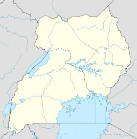
 Mbarara