London Borough d'Havering
- London Borough d'Havering
-
Havering
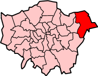
Le district londonien d'Havering (« London Borough of Havering ») est un district du Grand Londres. Cette circonscription, fondée en 1965 par fusion des districts d'Essex de Romford et d'Hornchurch, compte plus de 224 000 habitants.
Ce district se compose de :
- Ardleigh Green
- Chase Cross
- Collier Row
- Elm Park
- Emerson Park
- Gidea Park
- Harold Hill
- Harold Wood
- Havering-atte-Bower
- Hornchurch
- North Ockendon
- Rainham
- Romford
- Upminster
- Wennington
Jumelages
Liens externes
Wikimedia Foundation.
2010.
Contenu soumis à la licence CC-BY-SA. Source : Article London Borough d'Havering de Wikipédia en français (auteurs)
Regardez d'autres dictionnaires:
London Borough of Havering — Lage in Greater London Status London Borough Region … Deutsch Wikipedia
London Borough of Havering — Infobox London Borough | name = London Borough of Havering short name = Havering adminhq = Main Road, Romford imagename = status = London borough | area rank = 231st area km2 = 112.27 | area link = 1 E8 m² ons code = 00AR | ethnicity = 93.2%… … Wikipedia
Leader of the London Borough of Havering — The Leader of the London Borough of Havering is an annually elected position that occurs during the Annual Council Meeting of May each year. Since 2004, Cllr. Michael White, a Conservative Party politician and Member for Squirrels Heath Ward in… … Wikipedia
List of schools in the London Borough of Havering — This is a list of schools in the London Borough of Havering. The Borough is the education authority for the district providing education in a mix of foundation, community and voluntary aided schools.choolsPrimary and junior schoolsPrimary and… … Wikipedia
London Borough of Barking and Dagenham — Infobox London Borough | name = London Borough of Barking and Dagenham motto = short name = Barking and Dagenham adminhq = Rainham Road North, Becontree Heath imagename = status = London borough | area rank = 327th area km2 = 36.09 ons code =… … Wikipedia
London Borough of Bexley — Infobox London Borough | name = London Borough of Bexley short name = Bexley adminhq = Broadway, Bexleyheath imagename = status = London borough | area rank = 289th area km2 = 60.56 ons code = 00AD | url = [http://www.bexley.gov.uk/ LB Bexley]… … Wikipedia
London Borough of Southwark — London borough Coat of arms … Wikipedia
London Borough of Harrow — London borough Coat of arms … Wikipedia
London Borough of Merton — London borough Coat of arms … Wikipedia
London Borough of Tower Hamlets — Lage in Greater London Status London Borough Region … Deutsch Wikipedia