Loch Long (Argyll and Bute)

Loch Long (Argyll and Bute)

56°4′19,2″N 4°52′4,8″O / <span class="geo-dec geo" title="Cartes, vues aériennes et autres données pour Erreur d’expression : caractère de ponctuation « , » non reconnu. Erreur d’expression : caractère de ponctuation « , » non reconnu.">Erreur d’expression : caractère de ponctuation « , » non reconnu., Erreur d’expression : caractère de ponctuation « , » non reconnu.

Page d'aide sur l'homonymie Pour les articles homonymes, voir Loch Long.
LochLong(StevePartridge)Nov2007.jpg

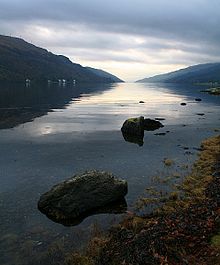
Le loch Long (Loch Long en gaélique écossais) est un loch de mer d'Écosse du comté d'Argyll and Bute.

Description

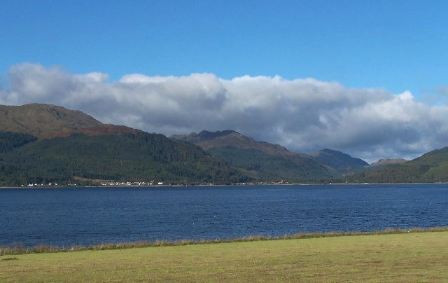
Le loch s'ouvre sur le Firth of Clyde à son extrémité sud-ouest. Il est long d'environ trente kilomètres, pour une largeur oscillant entre un et quatre kilomètres, et forme intégralement la côte de la Péninsule de Rosneath.

Le loch Long possède une branche, le loch Goil, sur son flanc ouest.

Les villages les plus importants situés sur le loch sont Arrochar, à la tête du loch, et Cove, sur la rive est, près de l'embouchure.

Histoire

Le loch vu en direction d'Ardentinny.

Jusqu'en 1996, le loch Long a marqué la frontière entre l'Argyll et le Dunbartonshire. Suite au remaniement des frontières qui eu lieu cette année-là, le loch est aujourd'hui entièrement compris dans le district d'Argyll and Bute.

Le loch fut utilisé durant la Seconde Guerre mondiale comme terrain d'essai de tir de torpilles, et contient toujours de nombreuses épaves. Le Ministère britannique de la Défense y possède encore aujourd'hui un embarcadère, et la Royal Navy y maintient un dépôt d'armement à Coulport, rattaché à la base navale de Faslane sur la rivière Clyde.

Le loch aujourd'hui

Il s'agit d'un site populaire de plongée ; un centre aquatique est d'ailleurs installé sur l'une des rives.

Le Finnart Oil Terminal, sur la rive est, est la terminaison d'un pipeline de presque cent kilomètres de long prenant son origine à la raffinerie de Grangemouth.


Wikimedia Foundation. 2010.

Contenu soumis à la licence CC-BY-SA. Source : Article Loch Long (Argyll and Bute) de Wikipédia en français (auteurs)

Игры ⚽ Поможем решить контрольную работу

Regardez d'autres dictionnaires:

  • Loch Long (Argyll and Bute) — Lage des Loch Long in Schottland …   Deutsch Wikipedia

  • Argyll and Bute — administrative division of Scotland: formerly a district * * * ▪ council area, Scotland, United Kingdom       council area, western Scotland, extending from the southwestern Grampian Mountains into the waters of the Atlantic Ocean and North… …   Universalium

  • Argyll and Bute — Pour les articles homonymes, voir Argyll (Écosse) et Île de Bute. Argyll and Bute Géogr …   Wikipédia en Français

  • Argyll and Bute — This article is about the council area. For the constituencies, see either Argyll and Bute (UK Parliament constituency) or Argyll and Bute (Scottish Parliament constituency) infobox Scotland council area Council= Argyll and Bute Council Earra… …   Wikipedia

  • Loch Long — Als Loch Long werden zwei Meeresbuchten (sea lochs) an der Westküste Schottlands bezeichnet: Loch Long (Argyll and Bute), Meeresbucht in der Region Argyll and Bute Loch Long (Highlands), Meeresbucht in den Northwest Highlands Diese Seite ist eine …   Deutsch Wikipedia

  • Tarbert, Argyll and Bute — infobox UK place country = Scotland official name= Tarbert gaelic name= An Tairbeart scots name= population= 1,338 (2001 Census) os grid reference= NR865685 latitude= 55.862805 longitude= 5.41143 unitary scotland= Argyll and Bute lieutenancy… …   Wikipedia

  • List of places in Argyll and Bute — This List of places in Argyll and Bute is a list of links for any town, village, hamlet, castle, golf course, historic house, lighthouse, nature reserve, reservoir, river, canal, and other place of interest in Argyll and Bute, Scotland,… …   Wikipedia

  • Arrochar, Argyll and Bute — Arrochar ( An t Arar or An Tairbeart Iar in Gaelic) is a village located near the head of Loch Long in Argyll and Bute, Scotland.It is overlooked by a group of mountains called the Arrochar Alps, and in particular by the distinctive rocky summit… …   Wikipedia

  • Cove, Argyll and Bute — For other meanings see Cove (disambiguation). Cove and the Rosneath peninsula seen from Blairmore, across Loch Long in Cowal Cove is a village in Argyll and Bute, Scotland. It is on the south west of the Rosneath peninsula, on the east shore of… …   Wikipedia

  • Crinan, Argyll and Bute — Looking out to Loch Crinan over the small inner harbour of Crinan Village. Crinan (Scottish Gaelic: An Crìonan) is a small village located on the west coast of Scotland in the region known as Knapdale, which is part of Argyll. The Crinan Canal… …   Wikipedia

Share the article and excerpts

Direct link
Do a right-click on the link above
and select “Copy Link”