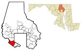
Lansdowne-Baltimore Highlands (Maryland)
Contenu soumis à la licence CC-BY-SA. Source : Article Lansdowne-Baltimore Highlands (Maryland) de Wikipédia en français (auteurs)
Regardez d'autres dictionnaires:
Lansdowne-Baltimore Highlands (Maryland) — Lansdowne Baltimore Highlands CDP de los Estados Unidos … Wikipedia Español
Lansdowne-Baltimore Highlands, Maryland — Infobox Settlement official name = Lansdowne Baltimore Highlands, Maryland settlement type = CDP nickname = motto = imagesize = image caption = image imagesize = image caption = image mapsize = 250x200px map caption = Location of Lansdowne… … Wikipedia
Lansdowne-Baltimore Highlands — Lansdowne Baltimore Highlands, MD U.S. Census Designated Place in Maryland Population (2000): 15724 Housing Units (2000): 6041 Land area (2000): 4.098165 sq. miles (10.614198 sq. km) Water area (2000): 0.181729 sq. miles (0.470676 sq. km) Total… … StarDict's U.S. Gazetteer Places
Lansdowne-Baltimore Highlands, MD — U.S. Census Designated Place in Maryland Population (2000): 15724 Housing Units (2000): 6041 Land area (2000): 4.098165 sq. miles (10.614198 sq. km) Water area (2000): 0.181729 sq. miles (0.470676 sq. km) Total area (2000): 4.279894 sq. miles (11 … StarDict's U.S. Gazetteer Places
Baltimore Highlands, Maryland — Baltimore Highlands is a unincorporated coummunity in southern Baltimore County, Maryland; just south of Baltimore city. The census combines the communities of Baltimore Highlands and Lansdowne (which are 1.5 miles apart… … Wikipedia
Lansdowne–Baltimore Highlands — uninc. place, CEN. Maryland 21227; pop. 15,509 … Webster's Gazetteer
Baltimore County, Maryland — Infobox U.S. County county = Baltimore County state = Maryland founded year = 1659 seat wl = Towson area total sq mi =682 area land sq mi =599 area water sq mi =83 area percentage = 12.23% census estimate yr = 2005 pop = 786113 density km2 =487… … Wikipedia
Baltimore County (Maryland) — Verwaltung US Bundesstaat: Maryland Verwaltungssitz: Towson Adresse des Verwaltungssitzes: Gründung … Deutsch Wikipedia
Woodlawn, Baltimore County, Maryland — Woodlawn Census designated place … Wikipedia
National Register of Historic Places listings in Baltimore County, Maryland — Location of Baltimore County in Maryland This is a list of the National Register of Historic Places listings in Baltimore County, Maryland. This is intended to be a complete list of the properties and districts on the National Register of… … Wikipedia
 États-Unis
 Maryland