Koghb
- Koghb
-
41° 10′ 57″ N 44° 58′ 33″ E / 41.1825, 44.975833
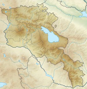
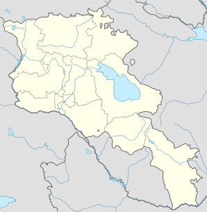
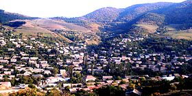
Koghb (en arménien Կողբ) est une communauté rurale du marz de Tavush, en Arménie. Elle compte 4 328 habitants en 2008[2].
Notes et références
- ↑ (hy+en) Central Electoral Commission of the Republic of Armenia. Consulté le 24 janvier 2011.
Pour obtenir la page en anglais, cliquez sur le drapeau arménien en haut à gauche, et sélectionnez « English » ; ensuite, dans le menu vertical de gauche, cliquez sur « Local », sélectionnez le
marz pertinent, puis la dernière élection correspondant à la communauté voulue.
- ↑ (en) ArmStat, Marzes of the Republic of Armenia in figures, 2008, « RA Tavush Marz », 2008. Consulté le 26 mars 2009.
Sur les autres projets Wikimedia :
Wikimedia Foundation.
2010.
Contenu soumis à la licence CC-BY-SA. Source : Article Koghb de Wikipédia en français (auteurs)
Regardez d'autres dictionnaires:
Koghb — may refer to: * Koghb, Armenia * Tuzluca, Turkey … Wikipedia
Koghb, Armenia — Infobox Settlement official name =Koghb Կողբ native name = pushpin mapsize =150px subdivision type = Country subdivision name = Armenia subdivision type1 = Marz (Province) subdivision name1 =Tavush leader title = leader name = established title … Wikipedia
Noyemberian — 41° 10′ N 44° 59′ E / 41.17, 44.99 … Wikipédia en Français
Eznik de Kolb — (ou de Koghb) ou Eznik Koghbatsi (en arménien Եզնիկ Կողբացի ; né vers 380, 390 ou 400, mort en 450 ou 455) est un théologien et philosophe arménien du Ve siècle, apologiste du christianisme. Il a laissé l ouvrage Réfutation des sectes,… … Wikipédia en Français
Treaty of Kars — Infobox Treaty name = Treaty of Kars long name = image width = 300px caption = The frontier established in the Treaty of Kars type = Peace Treaty date drafted = date signed = October 23, 1921 location signed = Kars, Turkey date sealed = date… … Wikipedia
Tuzluca — ( hy. Կոգհբ; Russian: Когб; Kurdish: Elîdizk; formerly known as Koghb, Kulp, and Goghb) is a town and district of Iğdır Province in the Eastern Anatolia region of Turkey. Part of the district forms the international border between Turkey and… … Wikipedia
Levon Ananyan — (born October 13 1946, Koghb, Tavush), is an Armenian journalist and translator.Levon Ananyan is a graduate of the Yerevan State University, Department of Philology. He has worked for a number of state journals. For approximately 25 years he… … Wikipedia
Noyemberyan — Coordinates: 41°10′21″N 44°59′37″E / 41.1725°N 44.99361°E / 41.1725; 44.99361 … Wikipedia
Prehistoric Armenia — The Armenian Highland shows traces of settlement from the Neolithic era. The Shulaveri Shomu culture of the central Transcaucasus region is the earliest known prehistoric culture in the area, carbon dated to roughly 6000 4000 BC. Another early… … Wikipedia
AM-ER — Eriwan Երևան Wappen Flagge … Deutsch Wikipedia
 Arménie