Alphen-Chaam
- Alphen-Chaam
-

Pour les articles homonymes, voir
Alphen.
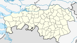
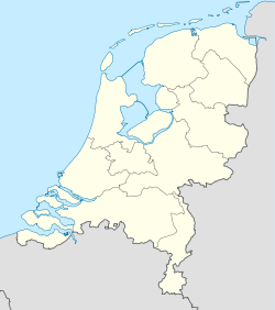
Alphen-Chaam est une commune des Pays-Bas de la province du Brabant-Septentrional.
Localités
Alphen, Alphen-Boshoven, Alphen-Oosterwijk, Boslust, Cauwelaar, Chaam, Chaamdijk, Druisdijk, Galder, Geersbroek, Ginderdoor, Grazen, Heerstaaien, Heikant, Het Sas, Hondseind, Houtgoor, Kalishoek, Klooster, Kwaalburg, Leg, Looneind, Meijsberg, Notsel, Rakens, Snijders-Chaam, Strijbeek, Terover, Venweg, 't Zand, Ulvenhout Alphen-Chaam.
Lien externe
|
|
| Hameaux et autres lieux |
Alphen-Boshoven • Alphen-Oosterwijk • Boslust • Cauwelaar • Chaamdijk • Druisdijk • Geersbroek • Ginderdoor • Grazen • Heerstaaien • Heikant • Hondseind • Houtgoor • Kalishoek • Klooster • Kwaalbrug • Leg • Looneind • Meijsberg • Notsel • Rakens • Het Sas • Snijders-Chaam • Terover • Venweg • 't Zand |
| Pays-Bas • Brabant-Septentrional • Communes des Pays-Bas |
Wikimedia Foundation.
2010.
Contenu soumis à la licence CC-BY-SA. Source : Article Alphen-Chaam de Wikipédia en français (auteurs)
Regardez d'autres dictionnaires:
Alphen-Chaam — Gemeinde Alphen Chaam Flagge Wappen Provinz Nordbrabant … Deutsch Wikipedia
Alphen-Chaam — Infobox Settlement official name = Alphen Chaam mapsize = 280px subdivision type = Country subdivision name = Netherlands subdivision type1 = Province subdivision name1 = North Brabant area footnotes = (2006) area total km2 = 93.64 area land km2 … Wikipedia
Heikant (Alphen-Chaam) — Heikant is a hamlet in the Dutch province of North Brabant. It is located in the municipality of Alphen Chaam VUGA s Alfabetische Plaatsnamengids van Nederland (13th edition), VUGA, 1997.] , about 2 km northeast of Chaam. ANWB Topografische Atlas … Wikipedia
't Zand, Alphen-Chaam — t Zand is a hamlet in the Dutch province of North Brabant, in the municipality of Alphen Chaam. Coordinates: 51°29′42″N 4°57′25″E / 51.495°N 4.9 … Wikipedia
't Zand (Alphen-Chaam) — t Zand is a hamlet in the Dutch province of North Brabant, in the municipality of Alphen Chaam … Wikipedia
Gemeente Alphen-Chaam — Admin ASC 2 Code Orig. name Gemeente Alphen Chaam Country and Admin Code NL.06.1723 NL … World countries Adminstrative division ASC I-II
Alphen — can refer to several towns in the Netherlands:* Alphen aan den Rijn (province of South Holland) * Alphen (South Holland), a former municipality, including Alphen aan den Rijn * Alphen (North Brabant) A village in the municipality Alphen Chaam… … Wikipedia
Alphen — ist der Name folgender Orte in den Niederlanden: Alphen aan den Rijn, in der Provinz von Südholland Alphen (Nordbrabant), ein Ort in der Region Alphen Chaam (Provinz Nordbrabant) Alphen (Gelderland), ein Ort in der Region West Maas en Waal… … Deutsch Wikipedia
Alphen (North Brabant) — Alphen is a village in the municipality of Alphen Chaam, in the Netherlands. It is located about 12 km southwest of Tilburg.The village itself has about 2960 inhabitants; the countryside that belongs to the village has a population of about… … Wikipedia
Alphen en Riel — is a former municipality in the Dutch province of North Brabant. It covered the villages of Alphen and Riel. In 1997, the municipality was divided between the new municipality of Alphen Chaam, and the municipality of Goirle.External links*… … Wikipedia


 Pays-Bas