Helcmanovce
- Helcmanovce
-
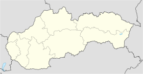
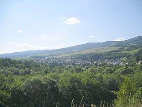
Helcmanovce (allemand : Hansdorf in der Zips) est un village de Slovaquie situé dans la région de Košice.
Histoire
Première mention écrite du village en 1297.
Notes et références
Catégories :
- Village de Slovaquie
- Village et ville du district de Gelnica
Wikimedia Foundation.
2010.
Contenu soumis à la licence CC-BY-SA. Source : Article Helcmanovce de Wikipédia en français (auteurs)
Regardez d'autres dictionnaires:
Helcmanovce — is a village and municipality in the Gelnica District in the Košice Region of eastern Slovakia … Wikipedia
District de Gelnica — Gelnica Informations Pays … Wikipédia en Français
Košice Region — Geobox | Region name = Košice other name = category = Region image caption = image caption = symbol = symbol type = Coat of arms etymology = official name = motto = nickname = country = Slovakia country state = region = district = commune =… … Wikipedia
Gelnica District — Infobox Slovak district subject name = Gelnica District region district slovak region = Košice Region population = 30,841 (2001) prefix = 53 area = 584 car plate = GL image location = Okres gelnica.png Gelnica District ( okres Gelnica ) is a… … Wikipedia
Margecany — Coordinates: 48°52′N 21°04′E / 48.867°N 21.067°E / 48.867; 21.067 … Wikipedia
Mníšek nad Hnilcom — Coordinates: 48°48′N 20°48′E / 48.8°N 20.8°E / 48.8; 20.8 … Wikipedia
Nálepkovo — Coordinates: 48°51′N 20°38′E / 48.85°N 20.633°E / 48.85; 20.633 … Wikipedia
List of municipalities and towns in Slovakia — Slovakia This is a comprehensive list of municipalities and towns in Slovakia. For lists of towns and municipalities sorted by Regions see the individual articles on Regions. For an outdated list of towns only in Slovakia see also List of towns… … Wikipedia
Szepes (county) — Infobox Former Subdivision native name = conventional long name = Szepes County common name = Szepes subdivision = County nation = the Kingdom of Hungary p1 = s1 = year start = 11th century event end = Treaty of Trianon year end = 1920 date end … Wikipedia
Bahnstrecke Margecany-Červená Skala — Margecany–Červená Skala Kursbuchstrecke (ZSSK): 173 Streckenlänge: 92,579 km Spurweite: 1435 mm (Normalspur) … Deutsch Wikipedia
 Slovaquie
 Helcmanovce