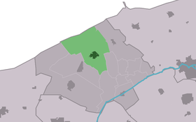
Ferwert
Contenu soumis à la licence CC-BY-SA. Source : Article Ferwert de Wikipédia en français (auteurs)
Regardez d'autres dictionnaires:
Ferwert — (Ferwerd) Flagge Wappen Provinz Friesland (Fryslân) Gemeinde … Deutsch Wikipedia
Ferwert — Infobox Settlement official name = Ferwert mapsize = 280px subdivision type = Country subdivision name = flagicon|Netherlands Netherlands subdivision type1 = Province subdivision name1 = flagicon|Friesland Friesland settlement type = Village… … Wikipedia
Ferwert — Original name in latin Ferwert Name in other language State code NL Continent/City Europe/Amsterdam longitude 53.33784 latitude 5.82533 altitude 1 Population 1935 Date 2009 08 17 … Cities with a population over 1000 database
Vakantiehuis Ferwert — (Ferwerd,Нидерланды) Категория отеля: Адрес: Hoofdstraat 4a , 9172 MP Ferwerd … Каталог отелей
Ferwerd — Ferwert 53°20′16″N 5°49′29″E / 53.33778, 5.82472 … Wikipédia en Français
Arp Schnitger — Schnitger Orgel in Cappel, 1680 Arp Schnitger (* 1648, vermutlich in Schmalenfleth; getauft am 9. Juli 1648 in Golzwarden, heute Brake; begraben 28. Juli 1719 in Neuenfelde, heute Hamburg) war einer der berühmtesten Orgelbauer seiner … Deutsch Wikipedia
Ferwerderadiel — Gemeinde Ferwerderadiel Flagge Wappen Provinz Friesland … Deutsch Wikipedia
Ferwerderadiel — Infobox Settlement official name = Ferwerderadiel image seal size = 70px mapsize = 280px subdivision type = Country subdivision name = Netherlands subdivision type1 = Province subdivision name1 = Friesland area footnotes = (2006) area total km2 … Wikipedia
Marrum — Village Coat of arms … Wikipedia
Bartlehiem — 53°16′36″N 5°50′31″E / 53.27667, 5.84194 … Wikipédia en Français
 Pays-Bas