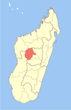
District de Fenoarivobe
- District de Fenoarivobe
-
Fenoarivobe ou Fenoarivo-Afovoany est un district de Madagascar, situé dans la partie nord-ouest de la province d'Antananarivo, dans la région de Bongolava.
Notes et références
Wikimedia Foundation.
2010.
Contenu soumis à la licence CC-BY-SA. Source : Article District de Fenoarivobe de Wikipédia en français (auteurs)
Regardez d'autres dictionnaires:
District de Tsiroanomandidy — Fenoarivobe Fenoarivo Afovoany Région Bongolava Chef lieu Fenoarivobe Nombre de kaominina 17 Superficie 8 977 … Wikipédia en Français
Fenoarivobe — 18° 27′ 00″ S 46° 33′ 18″ E / 18.45, 46.555 … Wikipédia en Français
Ambohitromby (Fenoarivobe) — 17° 57′ 54″ S 46° 19′ 12″ E / 17.965, 46.32 … Wikipédia en Français
Maritampona — Maritampona … Wikipedia
Ambatomainty Atsimo — Infobox Settlement official name = Ambatomainty Atsimo other name = native name = nickname = settlement type = motto = imagesize = image caption = flag size = image seal size = image shield = shield size = image blank emblem = blank emblem type … Wikipedia
Firavahana — Infobox Settlement official name = Firavahana other name = native name = nickname = settlement type = motto = imagesize = image caption = flag size = image seal size = image shield = shield size = image blank emblem = blank emblem type = blank… … Wikipedia
Kiranomena — Infobox Settlement official name = Kiranomena other name = native name = nickname = settlement type = motto = imagesize = image caption = flag size = image seal size = image shield = shield size = image blank emblem = blank emblem type = blank… … Wikipedia
Ambatomainty Atsimo — Administration Pays Madagascar … Wikipédia en Français
Firavahana — 18° 38′ 00″ S 46° 52′ 00″ E / 18.633333, 46.866667 … Wikipédia en Français
Kiranomena — 18° 17′ 00″ S 46° 03′ 00″ E / 18.283333, 46.05 … Wikipédia en Français


