Achterwetering

Achterwetering

52°9′1″N 5°9′7″E / 52.15028, 5.15194

Achterwetering
Administration
Pays Drapeau : Pays-Bas Pays-Bas
Province Utrecht
Commune De Bilt
Géographie
Population 90 hab. (2004)
Autres informations
Code postal
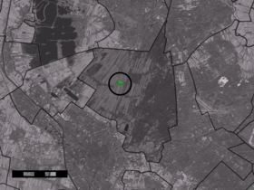
Localisation de Achterwetering dans la commune de De Bilt

Achterwetering est un hameau situé dans la commune néerlandaise de De Bilt, dans la province d'Utrecht. Le 1er janvier 2004, Achterwetering comptait 90 habitants.


Wikimedia Foundation. 2010.

Contenu soumis à la licence CC-BY-SA. Source : Article Achterwetering de Wikipédia en français (auteurs)

Игры ⚽ Нужно сделать НИР?

Regardez d'autres dictionnaires:

  • Achterwetering — Dutch town locator maps mun town caption = Achterwetering in the municipality of De Bilt.Achterwetering (coord|52|9|N|5|9|E|type:city(90)) is a village in the Dutch province of Utrecht. It is a part of the municipality of De Bilt, and lies about… …   Wikipedia

  • De Bilt —   Municipality   …   Wikipedia

  • Nieuwe-Wetering — For other uses, see Nieuwe Wetering (disambiguation). Nieuwe Wetering   Hamlet   …   Wikipedia

  • Achttienhoven (Utrecht) — 52° 08′ 54″ N 5° 08′ 20″ E / 52.1483, 5.13889 …   Wikipédia en Français

  • Bilthoven — 52°7′42″N 5°11′55″E / 52.12833, 5.19861 …   Wikipédia en Français

  • De Bilt — Héraldique …   Wikipédia en Français

  • Groenekan — 52°7′27″N 5°8′56″E / 52.12417, 5.14889 …   Wikipédia en Français

  • Hollandsche Rading — 52°10′30″N 5°10′45″E / 52.175, 5.17917 …   Wikipédia en Français

  • Maartensdijk — 52° 09′ 00″ N 5° 11′ 00″ E / 52.15, 5.18333 …   Wikipédia en Français

  • Westbroek — 52°9′3″N 5°7′33″E / 52.15083, 5.12583 …   Wikipédia en Français

Share the article and excerpts

Direct link
Do a right-click on the link above
and select “Copy Link”