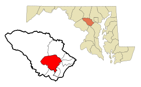
Columbia (Maryland)
Contenu soumis à la licence CC-BY-SA. Source : Article Columbia (Maryland) de Wikipédia en français (auteurs)
Regardez d'autres dictionnaires:
Columbia, Maryland — CDP The People Tree statue is considered a symbol of Columbia … Wikipedia
Columbia (Maryland) — Columbia CDP de los Estados Unidos … Wikipedia Español
Columbia (Maryland) — Columbia … Deutsch Wikipedia
Dorsey's Search, Columbia, Maryland — Dorsey s Search is one of ten villages comprising Columbia, Maryland, USA, and was occupied starting in 1980.[1] The current population is approximately 7,500. The village has two neighborhoods: Dorsey Hall and Fairway Hills. It is the… … Wikipedia
Owen Brown, Columbia, Maryland — Owen Brown is one of the 10 villages in Columbia, Maryland, USA, incorporated in 1972. Neighborhoods in the village include Dasher Green, Elkhorn, and Hopewell.[1] Owen Brown lies south and east of the Town Center.[2] The village contains the 37… … Wikipedia
Oakland Mills, Columbia, Maryland — Oakland Mills is one of the 10 villages in Columbia, Maryland. It is located immediately east of Town Center, across US Route 29.[1] Neighborhoods in the village of Oakland Mills include Steven s Forest, Talbott Springs, and Thunder Hill.[2]… … Wikipedia
River Hill, Columbia, Maryland — River Hill is the last village to be developed in the town of Columbia, Maryland, though numerous residents have addresses in Clarksville. It is home to about 6,500 residents. It is bounded by Maryland Route 108 and Maryland Route 32, and is… … Wikipedia
Wilde Lake, Columbia, Maryland — Wilde Lake is an artificial lake and a surrounding neighborhood, or village , located in Columbia, Maryland. It was the first portion of the New Town of Columbia to be built during the late 1960s. The lake itself is named for Frazar B. Wilde, a… … Wikipedia
Hammond High School (Columbia, Maryland) — Infobox Secondary school name = Hammond High School motto = Where People Are Important established = 1976 type = Public Secondary principal = Mr. Sterlind S. Burke students = 1313 (2005 ndash;2006) grades = 9–12 address= 8800 Guilford Road city … Wikipedia
Kings Contrivance, Columbia, Maryland — Kings Contrivance is one of the villages in the planned community of Columbia, Maryland, and is home to about 11,000 residents. It contains a Village Center (open air shopping center) and many apartment complexes and housing developments. Neither … Wikipedia
 Pour les articles homonymes, voir Columbia.
 États-Unis
 Maryland