Cape Barren Island
- Cape Barren Island
-
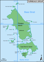
Archipel Furneaux

Carte de Tasmanie avec l'archipel Furneaux en haut à droite
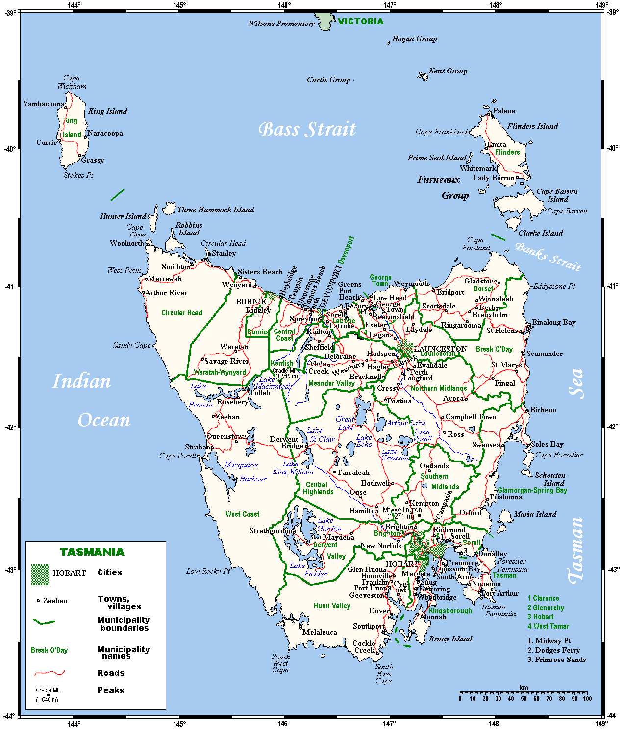
40°0′43″S 148°7′41″E / -40.01194, 148.12806 L'archipel Furneaux (en anglais: The Furneaux Group) est un ensemble de 52 îles tasmaniennes situées[1] à l'extrémité est du détroit de Bass entre la Tasmanie au sud et l'état de Victoria au nord, en Australie. Ces îles formaient une chaine de montagne dans la plaine qui reliait la Tasmanie au continent australien à l'époque glaciaire il y a entre 12 000 et 18 000 ans. Elles doivent leur nom à l'explorateur anglais Tobias Furneaux qui visita la région en 1773.
L'archipel bénéficie d'un climat tempéré doux avec des précipitations de 600 à 800 mm. Les vents peuvent être violents.
L'archipel compte environ 900 habitants.
La plus grande des îles est Flinders Island.
Plus au sud, il y a aussi Cape Barren Island et, encore plus au sud, Clarke Island qui sont, avec Flinders Island, les seules îles habitées en permanence de l'archipel. Elles font partie des Flinders Local government Area (voir zone d'administration locale).
Liens externes
- [1]site officiel de l'archipel
- [2] guide touristique de Flinders Island
Notes et références
 Portail du monde maritime
 Portail de l’Australie
Catégories : Archipel de l'océan Indien | Archipel d'Australie | Géographie de la Tasmanie
Wikimedia Foundation.
2010.
Contenu soumis à la licence CC-BY-SA. Source : Article Cape Barren Island de Wikipédia en français (auteurs)
Regardez d'autres dictionnaires:
Cape Barren Island — is located off the north east coast of Tasmania, Australia, and is one of the islands of the Furneaux Group in Bass Strait. The largest island of the group, Flinders Island, lies to the north, with the smaller Clarke Island to the south. The… … Wikipedia
Cape Barren Island — Satellitenaufnahme von Cape Barren Island (Mitte) Gewässer Bass Straße … Deutsch Wikipedia
Cape Barren Island — noun an island off the north eastern tip of Tasmania in Bass Strait, the second largest of the Furneaux Group; its lagoons form a Ramsar wetland site …
Cape Barren Goose — Conservation status Least Concern� … Wikipedia
Barren Island — may refer to:Andaman Islands * Barren Island (Andaman Islands)Australia * Barren Island (Tasmania) * Cape Barren Island, TasmaniaCanada * Barren Island (Nova Scotia) * Barren Island (Ontario)Falkland Islands * Barren Island (Falkland Islands)USA… … Wikipedia
Barren Island — kann sich beziehen auf: Barren Island (Andamanen), eine Insel der Andamanen Barren Island (Falklandinseln), eine der Falklandinseln Barren Island (New York), eine ehemalige Insel und jetziges Stadtviertel von New York Barren Island (Ontario),… … Deutsch Wikipedia
Cape Barren goose — noun a large goose, Cereopsis novaehollandiae, endemic to southern Australia, greyish in colour with pink legs and a black bill with prominent greenish cere; breeds on off shore islands. {named after Cape Barren Island, where the geese were first …
Cape Breton Island — Infobox Islands name = Cape Breton image caption = Cape Breton Island, Nova Scotia, Canada image size = locator Location map|Canada Nova Scotia|lat=46.166667|long= 60.75|marksize=16 map custom = yes native name = native name link = nickname =… … Wikipedia
Barren — as a place name can refer to: *Barren County, Kentucky *Barren Island (Andaman Islands) *Barren Island, Brooklyn *Barren River LakeBarren can also refer to: *Barren County (album) *Barren County Progress *Barren Realms Elite *Barren Strawberry… … Wikipedia
Clarke Island (Tasmania) — Clarke Island Lying below Flinders Island (the large land mass at the top of the image) and Cape Barren Island (the centre large island) is Clarke Island, roughly a quarter of the size of Cape Barren Island. The large land mass at the bottom left … Wikipedia
 L'archipel Furneaux