Burdaard
Contenu soumis à la licence CC-BY-SA. Source : Article Burdaard de Wikipédia en français (auteurs)
Regardez d'autres dictionnaires:
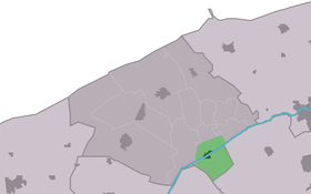
Burdaard — Infobox Settlement official name = Burdaard mapsize = 280px subdivision type = Country subdivision name = flagicon|Netherlands Netherlands subdivision type1 = Province subdivision name1 = flagicon|Friesland Friesland settlement type = Village… … Wikipedia
Burdaard — Original name in latin Burdaard Name in other language Birdaard, Burdaard State code NL Continent/City Europe/Amsterdam longitude 53.29421 latitude 5.87897 altitude 1 Population 1166 Date 2008 10 23 … Cities with a population over 1000 database
De Zwaluw, Burdaard — De Zwaluw, May 2008 Origin Mill name De Zwaluw Mill location Moun … Wikipedia
De Olifant, Burdaard — De Olifant, October 2008 Origin Mill name De Olifant Mill location Wier … Wikipedia
Birdaard — Burdaard 53°17′37″N 5°52′43″E / 53.29361, 5.87861 … Wikipédia en Français
De Hoop, Stiens — De Hoop Origin Mill name De Hoop Mill location Mo … Wikipedia
Ferwerderadiel — Infobox Settlement official name = Ferwerderadiel image seal size = 70px mapsize = 280px subdivision type = Country subdivision name = Netherlands subdivision type1 = Province subdivision name1 = Friesland area footnotes = (2006) area total km2 … Wikipedia
Kinderdijk — Coordinates: 51°53′N 4°38′E / 51.883°N 4.633°E / 51.883; 4.633 … Wikipedia
De Adriaan, Haarlem — Windmill De Adriaan De Adriaan is a windmill in the Netherlands that burnt down in 1932 and was rebuilt in 2002. The original windmill dates from 1779 and the mill has been a distinctive part of the skyline of Haarlem for centuries. Contents … Wikipedia
Ferwerderadiel — Gemeinde Ferwerderadiel Flagge Wappen Provinz Friesland … Deutsch Wikipedia
 Pays-Bas