Ugod
- Ugod
-
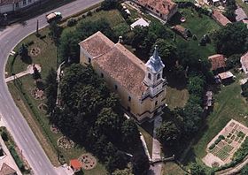
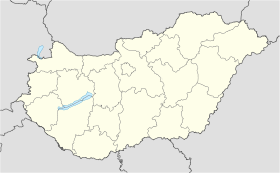
Ugod est un village et une commune du comitat de Veszprém en Hongrie.
Géographie
Cette section est vide, insuffisamment détaillée ou incomplète.
Votre aide est la bienvenue !
Histoire
Cette section est vide, insuffisamment détaillée ou incomplète.
Votre aide est la bienvenue !
Catégorie :
- Ville et village du comitat de Veszprém
Wikimedia Foundation.
2010.
Contenu soumis à la licence CC-BY-SA. Source : Article Ugod de Wikipédia en français (auteurs)
Regardez d'autres dictionnaires:
Ugod — Ugod, Dorf im Bezirk Papa des ungarischen Comitats Weszprim, am Bakonyerwalde, mit alkalisch salinischen Eisensäuerlingen u. 1750 Ew … Pierer's Universal-Lexikon
Ugod — Infobox Settlement subdivision type = Country subdivision name = HUN timezone=CET utc offset=+1 timezone DST=CEST utc offset DST=+2 pushpin pushpin label position = pushpin map caption =Location of Ugod pushpin mapsize = official name=Ugod… … Wikipedia
U-God — Infobox musical artist 2 Name = U God Img size = Background = solo singer Birth name = Lamont Jody Hawkins Born = Origin = Staten Island, New York City, New York, U.S. Genre = Hip hop Years active = 1993 ndash;present Label = Priority Records… … Wikipedia
Manytschniederung — Lage der Manytschniederung Die Manytschniederung (auch Kuma Manytsch Niederung; russisch Кумо Манычская впадина, Kuma Manytsch Senke) ist eine etwa 500 Kilometer lange Niederung zwischen der Kuban Asowschen Niederung und der Kaspischen… … Deutsch Wikipedia
Veszprém (county) — Infobox Hungarian county name =Veszprém region =Central Transdanubia seat = Veszprém area = 4613 population = 375,000 density = 81 cities = 217: For the historical county see Veszprém (former county). Veszprém (in Slovak Vesprím ) is the name of… … Wikipedia
Devecser — Aerial photography: Devecser Palace … Wikipedia
Kleingebiet Pápa — Das Kleingebiet Pápa (ungarisch pápai kistérség) ist eine ungarische Verwaltungseinheit (LAU 1) innerhalb des Komitat Veszprém in Ungarn. Der Verwaltungssitz ist Pápa. Ortschaften Die folgenden Ortschaften gehören zum Kleingebiet Pápa: Adásztevel … Deutsch Wikipedia
Ajka — Héraldique Administration … Wikipédia en Français
Balatonfüred — Héraldique … Wikipédia en Français
Csesznek — Héraldique Administration … Wikipédia en Français

 Hongrie
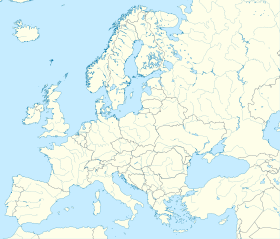

 Ugod
Ugod


