Szatmárcseke
- Szatmárcseke
-
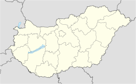
Szatmárcseke est un village et une commune du comitat de Szabolcs-Szatmár-Bereg en Hongrie.
Géographie
Cette section est vide, insuffisamment détaillée ou incomplète.
Votre aide est la bienvenue !
Histoire
Cette section est vide, insuffisamment détaillée ou incomplète.
Votre aide est la bienvenue !
Catégorie :
- Ville et village du comitat de Szabolcs-Szatmár-Bereg
Wikimedia Foundation.
2010.
Contenu soumis à la licence CC-BY-SA. Source : Article Szatmárcseke de Wikipédia en français (auteurs)
Regardez d'autres dictionnaires:
Szátmárcseke — Sp Sãtmarčekė Ap Szátmárcseke L Vengrija … Pasaulio vietovardžiai. Internetinė duomenų bazė
Tur River — Geobox River name =Tur River native name = other name = other name1 = image size = image caption = country type = Countries state type = region type = district type = Counties city type = Villages country = Romania country1 = Hungary state =… … Wikipedia
Tur (Tisza) — la Tur Rivières roumaines Caractéristiques Longueur 94 km Bassin 1 261 km2 … Wikipédia en Français
Nyíregyháza — City center … Wikipedia
Szabolcs-Szatmár-Bereg County — Infobox Hungarian county name =Szabolcs Szatmár Bereg region =Northern Great Plain seat = Nyíregyháza area = 5936 population = 572,423 density = 96 cities = 228Szabolcs Szatmár Bereg is an administrative county (Hungarian: megye ) in north… … Wikipedia
Máriapócs — Country Hungary County Szabolcs Szatmár Bereg Area Total 22.09 km2 (8 … Wikipedia
Ferenc Kölcsey — (August 8, 1790 August 24, 1838) was a Hungarian poet, literary critic, orator, and politician, noted for his support of the liberal current inside the Austrian Empire. BiographyKölcsey was born in Szatmárcseke, Hungary. He was orphaned at an… … Wikipedia
Nagykálló — Country Hungary County Szabolcs Szatmár Bereg Area – Total 68.55 km2 (26 … Wikipedia
Nyírtass — Country Hungary County Szabolcs Szatmár Bereg Area Total 37.95 km2 (14 … Wikipedia
Baktalórántháza — Market Town Aerial photograph: Baktalórántháza Palace … Wikipedia


 Hongrie

 Szatmárcseke


