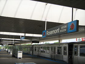
Rosemont (CTA)

Rosemont (CTA)
Rosemont Wheelchair symbol.svgParkeerplaats.png
Rosemont blue line CTA.jpg
5801 N. River Road
Rosemont, Illinois 60018
Localisation
Pays États-Unis
Ville Rosemont
Coordonnées géographiques 41° 59′ 01″ N 87° 51′ 34″ E / 41.983507, 87.85938841° 59′ 01″ N 87° 51′ 34″ E / 41.983507, 87.859388  
Gestion et exploitation
Services Métro de Chicago


Caractéristiques
Quais 1
Historique
Mise en service 27 février 1983
Correspondances
Bus Bus Pace

Rosemont (connue sous le nom de River Road jusqu’en 1990) est une station de la ligne bleue du métro de Chicago située à 25 km au nord-ouest du Loop à proximité de la Kennedy Expressway.

Rosemont est accessible aux personnes à mobilité réduite, 1.612.758 passagers l’ont utilisée en 2008[1].

Sommaire

Histoire

Dernière station de la première extension de la O'Hare Branch, elle a ouvert ses portes le 27 février 1983 et servait de terminus de la ligne bleue jusqu’à l’ouverture de la station O'Hare un an plus tard. Elle fut conçue par la firme de Metz, Train & Youngren, sa plate-forme contient une série de puits de lumière pour laisser entrer la lumière naturelle. Un parking de dissuasion pour 798 véhicules y est disponible[2].

Desserte

La station est ouverte 24h/24 et 7jours/7 et est desservie toutes les sept minutes en heure creuse dans chaque sens pour deux minutes en heure de pointe.

Rosemont
Départ Station précédente Ligne Station suivante Terminus
ForestPark.png Cumberland   O'Hare OHare.png

Correspondances

Avec le les bus Pace

  • #221 Wolf Road
  • #222 Allstate Arena Express
  • #223 Elk Grove-Rosemont CTA Station
  • #230 South Des Plaines
  • #284 Six Flags Great America Express
  • #325 25th Avenue
  • #326 West Irving Park
  • #332 River-York Roads
  • #600 Northwest Express
  • #606 Northwest Limited
  • #610 River Road-Prarie Stone Express
  • #616 The Chancellory Connection
  • #637 Wood Dale-Rosemont CTA Station [ends February 7, 2010]
  • #889 Harvey/Blue Island-Rosemont Express

Notes et références

Voir aussi

Articles connexes


Wikimedia Foundation. 2010.

Contenu soumis à la licence CC-BY-SA. Source : Article Rosemont (CTA) de Wikipédia en français (auteurs)

Игры ⚽ Нужно сделать НИР?

Regardez d'autres dictionnaires:

  • Rosemont (CTA) — Rosemont is the L station at the intersection of River Rd. and I 190. It is located in the median of I 190 with one island platform serving two tracks, 16 miles (25 km) northwest of the Chicago Loop. Trains are scheduled to depart from Rosemont… …   Wikipedia

  • Rosemont, Illinois — Geobox|Settlement name = Rosemont native name = other name = category = Village etymology = official name = motto = nickname = image caption = River Road in Rosemont symbol = country = United States state = Illinois region = Cook region type =… …   Wikipedia

  • Cumberland (CTA) — Cumberland 5800 N. Cumberland Avenue Chicago, Illinois 60631 …   Wikipédia en Français

  • Cumberland (CTA station) — Cumberland …   Wikipedia

  • O'Hare (CTA station) — O Hare …   Wikipedia

  • Forest Park (CTA station) — Forest Park …   Wikipedia

  • Grand (CTA) — Grand 502 N. Milwaukee Avenue Chicago, Illinois 60622 Localisation Pays …   Wikipédia en Français

  • Harlem (Ligne bleue nord CTA) — Harlem 5550 N. Harlem Avenue Chicago, Illinois 60656 …   Wikipédia en Français

  • Pulaski (Ligne bleue CTA) — Pulaski 530 S. Pulaski Road, Chicago, Illinois 60612 Localisation Pays …   Wikipédia en Français

  • Irving Park (CTA Blue Line) — Irving Park is a station on the Chicago Transit Authority s L system, serving the Blue Line. The station is located at coord|41.952964| 87.729263|display=inline,title in the median of the Kennedy Expressway. Irving Park is one of two stations… …   Wikipedia

Share the article and excerpts

Direct link
Do a right-click on the link above
and select “Copy Link”