Bengtskär
- Bengtskär
-
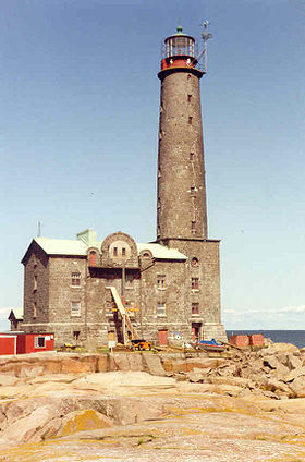
Bengtskär est une petite île du golfe de Finlande. Elle est rattachée à la commune de Dragsfjärd. Le seul bâtiment est un phare qui est la construction la plus méridionale de la Finlande. Construit en 1906, le phare a été largement restauré entre 1985 et 1995 et abrite un hôtel ouvert en été. L'île est devenue au cours des dernières années une importante destination touristique et voit passer chaque année 10 000 visiteurs, dont 1 000 y passent au moins une nuit.
Annexes
Articles connexes
Liens externes
Catégories :
- Île du golfe de Finlande
- Île de Finlande
Wikimedia Foundation.
2010.
Contenu soumis à la licence CC-BY-SA. Source : Article Bengtskär de Wikipédia en français (auteurs)
Regardez d'autres dictionnaires:
Bengtskär — is a skerry 25 kilometers southwest of Hanko, and part of the municipality of Dragsfjärd. This rocky skerry is the southern most inhabited place in Finland, and is reached by ferry from the village of KasnäsThe lighthouse on the skerry is the… … Wikipedia
Bengtskar — Bengtskär Géographie Pays Finlande Archipel Archipel finlandais Localisation Golfe de Finlande ( … Wikipédia en Français
Bengtskär — Vorlage:Infobox Insel/Wartung/Bild fehltVorlage:Infobox Insel/Wartung/Höhe fehlt Bengtskär Gewässer Ostsee Geographische Lage … Deutsch Wikipedia
Battle of Hanko (1941) — Battle of Hanko Part of Continuation War Map showing the borders of the leased area … Wikipedia
Hanko — (pronounced|ˈhɑŋko) in Finnish, Hangö in Swedish, and Гангут in Russian), is a bilingual port town on the south coast of Finland, 130 km west of Helsinki. Its current population is 9,905 (2004 12 31), with a majority being Finnish speakers and a… … Wikipedia
Märket — Localización País … Wikipedia Español
HNoMS Olav Tryggvason — The minelayer HNoMS Olav Tryggvason was built for the Royal Norwegian Navy by the naval shipyard at Horten in the early 1930s and had build number 119. [Horten municipal archive of local history: [http://www.lokalhistoriskarkiv.no/arkivet/historis… … Wikipedia
VMV class patrol boat — ( fi. Vartiomoottorivene) was a series of Finnish patrol boats, which served with the Finnish Coast Guard and the Finnish Navy during World War II.DevelopmentThe VMV boats were designed by dipl.eng. Jaakko Rahola of the Finnish Navy. The design… … Wikipedia
Kemiönsaari — Kimitoön kommun Kemiönsaaren kunta Wappen Karte Basisdaten … Deutsch Wikipedia
Liste deutscher Leuchttürme — In diesem Artikel oder Abschnitt fehlen folgende wichtige Informationen: Es fehlen beispielsweise noch dänische Leuchttürme Du kannst Wikipedia helfen, indem du sie recherchierst und einfügst … Deutsch Wikipedia
 Finlande
 Bengtskär
