Bella Coola
- Bella Coola
-

Cet article concerne la ville de Colombie-Britannique. Pour la tribu indienne, voir
Nuxalk.
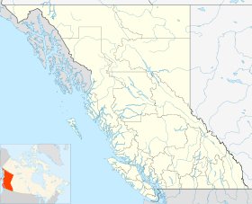
Bella Coola est une ville canadienne de la Colombie-Britannique située dans la <division de recensement> et la région administrative de <région>.
Situation
Bella Coola est située le long du bras nord du détroit de Burke.
Chronologie municipale
Histoire
C'est à Bella Coola le 22 juillet 1792, que Alexander Mackenzie atteint l'océan Pacifique lors de sa traversée du Canada, il est alors le premier Européen à avoir traversé le continent nord-américain d'est en ouest.
Toponyme
Économie
Municipalités limitrophes
 |
|
??? |
|
|
| ??? |
N |
??? |
| O ??? E |
| S |
|
??? |
|
Voir aussi
Liens externes
Wikimedia Foundation.
2010.
Contenu soumis à la licence CC-BY-SA. Source : Article Bella Coola de Wikipédia en français (auteurs)
Regardez d'autres dictionnaires:
Bella Coola — Lage in British Columbia … Deutsch Wikipedia
Bella Coola — may refer to several things, all closely related to a geographic area within British Columbia s Central Coast:*The Nuxálk, an indigenous people of the area who in the past had been referred to as the Bella Coola *The Nuxálk language spoken by… … Wikipedia
Bella-Coola — Verbreitung der Salish Sprachen Die Bellacoola oder Nuxalk sind ein Indianer Stamm aus der Sprachfamilie der Salish. Sie leben an den Ufern des Bella Coola Rivers in British Columbia, in einem bis 1906 bzw. 1955 isolierten Fischerdorf. Heute… … Deutsch Wikipedia
Bella Coola — ▪ people also called Nuxalk North American Indians whose villages were located in what is now the central British Columbia coast, along the upper Dean and Burke channels and the lower parts of the Bella Coola River valley. They spoke a… … Universalium
Bella Coola — Sp Bèla Kulà Ap Bella Coola L u., mst. Kanadoje (Britų Kolumbija) … Pasaulio vietovardžiai. Internetinė duomenų bazė
Bella Coola, British Columbia — Bella Coola is a community of approximately 600 at the western extremity of the Bella Coola valley. Bella Coola usually refers to the entire valley, encompassing the settlements of Bella Coola proper ( the townsite ), Lower Bella Coola,… … Wikipedia
Bella Coola River — Bella Coola RiverVorlage:Infobox Fluss/GKZ fehlt Lage British Columbia (Kanada) Flusssystem Bella Coola River Abfluss über Bella Coola River → North Bentinck Arm → Pazifischer Ozean … Deutsch Wikipedia
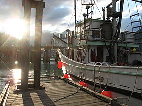
Bella Coola (Colombie-Britannique) — Bella Coola Cet article concerne la ville de Colombie Britannique. Pour la tribu indienne, voir Nuxalk. Bella Coola Le port de Bella Coola … Wikipédia en Français
Bella Coola Mountain Lodge — (Hagensborg,Канада) Категория отеля: 4 звездочный отель Адрес: 1900 Highw … Каталог отелей
Bella Coola River — The Bella Coola River is a major river on the Pacific slope of the Coast Mountains in southern British Columbia. The town of Bella Coola, which is the historic and ancient capital of the Nuxalk people, is at its mouth on North Bentinck Arm. Bella … Wikipedia
 Canada
 Colombie-Britannique