Kemecse
- Kemecse
-
Kemecse est une ville et une commune du comitat de Szabolcs-Szatmár-Bereg en Hongrie.
Géographie
Cette section est vide, insuffisamment détaillée ou incomplète.
Votre aide est la bienvenue !
Histoire
Cette section est vide, insuffisamment détaillée ou incomplète.
Votre aide est la bienvenue !
Catégories :
- Ville et village du comitat de Szabolcs-Szatmár-Bereg
- Ville de Hongrie
Wikimedia Foundation.
2010.
Contenu soumis à la licence CC-BY-SA. Source : Article Kemecse de Wikipédia en français (auteurs)
Regardez d'autres dictionnaires:
Kemecse — Infobox Settlement settlement type = subdivision type = Country subdivision name = HUN latd= |latm= |lats= |latNS=N longd= |longm= |longs= |longEW=Epushpin pushpin label position = pushpin map caption = pushpin mapsize = timezone=CET utc… … Wikipedia
Kemecse — Original name in latin Kemecse Name in other language Kemecse State code HU Continent/City Europe/Budapest longitude 48.07532 latitude 21.80625 altitude 97 Population 5029 Date 2012 01 18 … Cities with a population over 1000 database
Kemecse — … Википедия
Szabolcs-Szatmár-Bereg — 48°00′N 22°10′E / 48, 22.167 … Wikipédia en Français
Кемече — Город Кемече венг. Kemecse Герб … Википедия
Nemzeti Bajnokság III — NB III (Nemzeti Bajnokság III, National Championship III) is the third tier of Hungarian football (from the autumn of 1997 till the spring of 2005, NB III was the fourth tier, the third was NB II). The tier contains 6 groups of 15 16 teams. From… … Wikipedia
List of cities and towns in Hungary — Hungary This article is part of the series: Politics and government of Hungary Constitution President … Wikipedia
Nyíregyháza — City center … Wikipedia
Szabolcs-Szatmár-Bereg County — Infobox Hungarian county name =Szabolcs Szatmár Bereg region =Northern Great Plain seat = Nyíregyháza area = 5936 population = 572,423 density = 96 cities = 228Szabolcs Szatmár Bereg is an administrative county (Hungarian: megye ) in north… … Wikipedia
Máriapócs — Country Hungary County Szabolcs Szatmár Bereg Area Total 22.09 km2 (8 … Wikipedia


 Hongrie

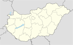
 Kemecse


