Godden Green
- Godden Green
-
Godden Green est un hameau situé dans le civil parish de Seal dans le district de Sevenoaks, il et à 1 mile (2 km) de la ville de Sevenoaks dans le Kent.
Sur les autres projets Wikimedia :
Wikimedia Foundation.
2010.
Contenu soumis à la licence CC-BY-SA. Source : Article Godden Green de Wikipédia en français (auteurs)
Regardez d'autres dictionnaires:
Godden Green — infobox UK place country = England official name=Godden Green static static image caption= latitude= 51.272400 longitude=0.223330 population = civil parish= shire district=Sevenoaks shire county= Kent region= South East England constituency… … Wikipedia
Dunton Green — Coordinates: 51°17′47″N 0°10′18″E / 51.29648°N 0.17160°E / 51.29648; 0.17160 … Wikipedia
New Ash Green — is a village near the ancient village of Ash, in the parish of Ash cum Ridley, about 6 miles (10 km) south of Gravesend in Kent and 21 miles (34 km) south east of London. Building of the village began in 1967, with Span as the developer … Wikipedia
Marsh Green, Kent — Marsh Green is a small hamlet in Eden Vale, part of the parish of Edenbridge, England. The hamlet was founded in 1554 under its current name. Marsh Green claims the last bare knuckle boxing fight in England, in 1886. External links Marsh Green … Wikipedia
Ashbee, Charles Robert — ▪ British architect and designer born May 17, 1863, Isleworth, Middlesex, Eng. died May 23, 1942, Godden Green, Sevenoaks, Kent English architect, designer, and leader of the Arts and Crafts Movement in England during the latter part of the … Universalium
List of schools in Kent — List of primary schools, middle schools, secondary schools, special schools, further education colleges and universities in the ceremonial county of Kent, England. [cite web | title = UK Schools Colleges Database | publisher = Schools Web… … Wikipedia
Sevenoaks — For the parliamentary constituency, see Sevenoaks (UK Parliament constituency). For the Community in Wesley Chapel Florida, see Seven Oaks Community. Coordinates: 51°16′41″N 0°11′15″E / … Wikipedia
Chevening, Kent — Coordinates: 51°17′34″N 0°08′23″E / 51.292760°N 0.139700°E / 51.292760; 0.139700 … Wikipedia
Chipstead, Kent — Coordinates: 51°17′07″N 0°08′57″E / 51.285250°N 0.149050°E / 51.285250; 0.149050 … Wikipedia
Otford — For the town of this name in Australia, see Otford, New South Wales. Coordinates: 51°18′35″N 0°11′12″E / 51.30969°N 0.18657°E / 51 … Wikipedia
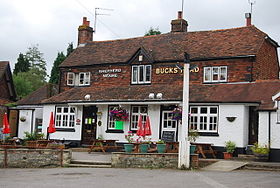 Pub Buck's Head
 Angleterre
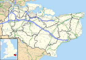
 Godden Green
