Derbyhaven

Derbyhaven

54° 04′ 42″ N 4° 37′ 35″ W / 54.0784, -4.6265

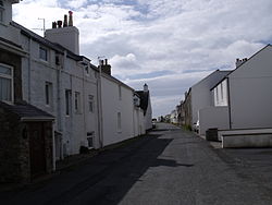
Une rue de Derbyhaven.

Derbyhaven (Camys y Ree en mannois) est un village de l'île de Man, situé dans la paroisse de Malew. Son nom signifiant « Port de Derby » vient des comtes de Derby et notamment de Thomas Stanley, 2e comte de Derby, qui le nomme ainsi en 1507[1]. Le nom précédent de Derbyhaven était Rognvald's Vagir, en vieux norrois, ou Ronaldsway, en anglais[1]. Au XVIIe siècle, Derbyhaven est le plus important port de pêche de l'île de Man[1].

Sommaire

Géographie

Situation

Plage de galets à Derbyhaven et, au fond, nord de la péninsule de Langness et île St Michael.

Derbyhaven se situe au sud-est de l'île de Man, à 3 km à l'est de la ville de Castletown dont elle est séparée par la péninsule de Langness. En quittant Castletown par la route A12 qui, depuis la colline de Hango, mène à l'aéroport du Ronaldsway, le visiteur arrive à Derbyhaven en longeant le King William's College[2]. Une fois dans le bourg, suivre l'A12 mène à l'aéroport. La péninsule de Langness est accessible en empruntant une petite route qui part vers le sud.

Personnalités liées à Derbyhaven

Annexes

Notes et références

  1. a, b et c (en) An illustrated encyclopedia of the Isle of Man, The Manx Experience, Douglas, 1997, p. 49.
  2. (en) « Derbyhaven, 1868 », isle-of-man.com.

Article connexe

Lien externe


Wikimedia Foundation. 2010.

Contenu soumis à la licence CC-BY-SA. Source : Article Derbyhaven de Wikipédia en français (auteurs)

Игры ⚽ Нужно сделать НИР?

Regardez d'autres dictionnaires:

  • Derbyhaven — Coordinates: 54°04′42″N 4°37′35″W / 54.0784°N 4.6265°W / 54.0784; 4.6265 …   Wikipedia

  • St. Michael's Isle — ( gv. Ellan Noo Mael), popularly referred to as Fort Island ( gv. Ynnys Vaayl), is an island of the Isle of Man, noted for its attractive ruins. It is connected to the Langness Peninsula, Derbyhaven by a narrow causeway.There are two ancient… …   Wikipedia

  • Langness Peninsula — Langness ( gv. Langlish) is a peninsula which protrudes from the south eastern extremity of the Isle of Man. Signifying a cape or extended promontory, Langness literally means long promontory in Old Norse. At one time an island, Langness was… …   Wikipedia

  • Malew — Parish of Malew Details Population: 2262 Sheading: Rushen …   Wikipedia

  • Illiam Dhone — William Christian Portrait de William Christian, Anonyme, National Art Gallery, Manx Museum, Douglas. Avec l aimabl …   Wikipédia en Français

  • List of places in the Isle of Man — This is a list of places in the Isle of Man. In addition to the Isle of Man itself, the Isle of Man Government administers three small neighbouring islands: the Calf of Man, St Patrick s Isle and St Michael s Isle. There are four places with… …   Wikipedia

  • List of bays of the British Isles — This is a list of bays of the British Isles, geographically by island. They are listed by island, in clockwise order, from the stated starting point.BritainClockwise from the River Tweed:England from the River Tweed to the Bristol Channel*Budle… …   Wikipedia

  • Langlish — Péninsule de Langness 54° 03′ 45″ N 4° 37′ 16″ W / 54.0625, 4.6212 …   Wikipédia en Français

  • Peninsule de Langness — Péninsule de Langness 54° 03′ 45″ N 4° 37′ 16″ W / 54.0625, 4.6212 …   Wikipédia en Français

  • Péninsule de Langness — 54° 03′ 45″ N 4° 37′ 16″ W / 54.0625, 4.6212 …   Wikipédia en Français

Share the article and excerpts

Direct link
Do a right-click on the link above
and select “Copy Link”