Bjørkelangen
Contenu soumis à la licence CC-BY-SA. Source : Article Bjørkelangen de Wikipédia en français (auteurs)
Regardez d'autres dictionnaires:
Bjørkelangen — ist der Hauptort der norwegischen Gemeinde Aurskog Høland ein 2,86 km² großer Binnensee in Aurskog Høland der Name einer 1924 in Chemnitz gebauten Dampflok, die bis zur Einstellung des Betriebs 1961 auf der Urskog Hølandsbahn verkehrte. Heute… … Deutsch Wikipedia
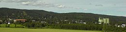
Bjørkelangen — Infobox Settlement name = Bjørkelangen official name = other name = native name = nickname = settlement type = Village total type = motto = imagesize = image caption = Bjørkelangen seen from Eidslia flag size = image seal size = image shield =… … Wikipedia
Bjorkelangen — Original name in latin Bjrkelangen Name in other language Bjorkelangen, Bjrkelangen State code NO Continent/City Europe/Oslo longitude 59.88478 latitude 11.56942 altitude 133 Population 2346 Date 2010 12 07 … Cities with a population over 1000 database
Bjørkelangen — Sp Bjòrkelangenas Ap Bjørkelangen L P Norvegija … Pasaulio vietovardžiai. Internetinė duomenų bazė
Bjørkelangen Videregående Skole — is located in the town of Bjørkelangen in Aurskog Høland muncipality in Norway. It is a high school with approximately 650 students. cite web |title=number of students at Bjørkelangen Videregående Skole… … Wikipedia
Bjørkelangen (lake) — infobox lake lake name = Bjørkelangen basin countries= Norway location = Aurskog Høland (Akershus) inflow = outflow = area = 2.86 km² elevation = 124 m residence time = shore = 14.07 km depth = max depth = volume = coords =… … Wikipedia
Aurskog-Høland — Wappen Karte … Deutsch Wikipedia
Aurskog-Høland — Infobox Kommune name=Aurskog Høland idnumber=0221 county=Akershus landscape=Romerike capital=Bjørkelangen governor=Jan Mærli (Ap) governor as of=2007 arearank=111 area=962 arealand=894 areapercent=0.30 population as of=2004 populationrank=79… … Wikipedia
List of schools in Norway — Schools in Norway are usually divided into the following categories: elementary schools ( barneskole ) 1st to 7th grade, lower secondary schools ( ungdomsskole ) 8th to 10th grade, upper secondary schools ( videregående skole ) 11th to 13th grade … Wikipedia
Chronology of Norwegian railway lines — New railway lines (with extensions) Year Line name Termini Length Gauge Electrified Ownership Other events/Current status 1854 Hoved Line Kristiania (Oslo) Eidsvoll 67.8 km Standard 1927: Oslo Ø–Lillestrøm 1953: Lillestrøm–Eidsvoll Private … Wikipedia


 Norvège