Zoravan
- Zoravan
-
40° 21′ 25″ N 44° 31′ 23″ E / 40.356944, 44.523056
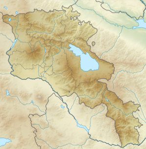
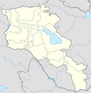
Zoravan (en arménien Զորավան ; anciennement Pokravan[2]) est une communauté rurale du marz de Kotayk, en Arménie. Elle compte 1 566 habitants en 2008[3].
Notes et références
- ↑ (hy+en) Central Electoral Commission of the Republic of Armenia. Consulté le 24 janvier 2011.
Pour obtenir la page en anglais, cliquez sur le drapeau arménien en haut à gauche, et sélectionnez « English » ; ensuite, dans le menu vertical de gauche, cliquez sur « Local », sélectionnez le
marz pertinent, puis la dernière élection correspondant à la communauté voulue.
- ↑ (en) Brady Kiesling, Rediscovering Armenia, 2000, p. 61 [lire en ligne (page consultée le 25 mars 2010)] .
- ↑ (en) ArmStat, Marzes of the Republic of Armenia in figures, 2008, « RA Kotayk Marz », 2008. Consulté le 12 mai 2009.
Wikimedia Foundation.
2010.
Contenu soumis à la licence CC-BY-SA. Source : Article Zoravan de Wikipédia en français (auteurs)
Regardez d'autres dictionnaires:
Zoravan — Infobox Settlement official name =Zoravan Զորավան native name = pushpin mapsize =150px subdivision type = Country subdivision name = Armenia subdivision type1 = Marz (Province) subdivision name1 =Kotayk leader title = leader name = established… … Wikipedia
Zoravan — Original name in latin Zoravan Name in other language Kargavank, Pokravan, Zoravan, Зораван State code AM Continent/City Asia/Yerevan longitude 40.35326 latitude 44.52319 altitude 1466 Population 1167 Date 2012 01 17 … Cities with a population over 1000 database
Championnat d'Arménie de football 1992 — Infobox compétition sportive Premier Liga 1992 Édition 1re Participants 24 Promu(s) Aucun (première édition) … Wikipédia en Français
Hrazdan — For other places with the same name, see Hrazdan (disambiguation). Hrazdan Հրազդան Hrazdan … Wikipedia
Tsaghkadzor — For the village in Azerbaijan, see Tsaxkadzor. Tsaghkadzor Ծաղկաձոր General view of the Tsaghkadzor valley … Wikipedia
Nor Hachn — Coordinates: 40°18′07″N 44°34′59″E / 40.30194°N 44.58306°E / 40.30194; 44.58306 … Wikipedia
Charentsavan — Coordinates: 40°24′35″N 44°38′35″E / 40.40972°N 44.64306°E / 40.40972; 44.64306 … Wikipedia
FC Yeghvard — is an Armenian football club from Yeghvard. The club participated as Zoravan Yeghvard in the first ever Armenian football competition after the split up from the Soviet Union. After the regular competition they did not qualify for the… … Wikipedia
1993 in Armenian football — was the second season of indepentent football after the split up from the Soviet Union. Professional football existed of two divisions, the Armenian Premier League (containing 16 teams) and the Armenian First League (1 group of 12 and 1 group of… … Wikipedia
Arzakan — Coordinates: 40°26′58″N 44°36′23″E / 40.44944°N 44.60639°E / 40.44944; 44.60639 … Wikipedia
 Arménie