Wieringerwaard
Contenu soumis à la licence CC-BY-SA. Source : Article Wieringerwaard de Wikipédia en français (auteurs)
Regardez d'autres dictionnaires:
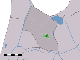
Wieringerwaard — Dutch town locator maps mun town caption = The village centre (dark green) and the statistical district (light green) of Wieringerwaard in the municipality of Anna Paulowna.Wieringerwaard (coord|52|50|N|4|52|E|type:city(1176)) is a polder and a… … Wikipedia
Bed en Breakfast De Pauw — (Wieringerwaard,Нидерланды) Категория отеля: Адрес: Noord Zijperweg 83, 17 … Каталог отелей
Selma Borst — Infobox athlete biography athletename = Selma Borst fullname = Selma Borst nickname = height = 1.70 m weight = 55 kg dateofbirth = Birth date and age|1983|9|6|df=y cityofbirth = Wieringerwaard countryofbirth = Netherlands personalbest = 1500… … Wikipedia
Anna Paulowna — Héraldique … Wikipédia en Français
Anna Visscher — Pour les articles homonymes, voir Visscher. Anna Visscher … Wikipédia en Français
Anna Paulowna — Infobox Settlement official name = Anna Paulowna imagesize = 275px image caption = Church and the old center of the village Anna Paulowna. flag size = 125px image shield = Wapenap.jpg shield size = 115px mapsize = 280px subdivision type = Country … Wikipedia
Kinderdijk — Coordinates: 51°53′N 4°38′E / 51.883°N 4.633°E / 51.883; 4.633 … Wikipedia
List of places in the Netherlands — This is an alphabetical list of places (cities, towns, villages) in the Netherlands. Lists per province can be found at:* List of towns in Groningen * List of towns in Friesland * List of towns in Drente * List of towns in Overijssel * List of… … Wikipedia
De Adriaan, Haarlem — Windmill De Adriaan De Adriaan is a windmill in the Netherlands that burnt down in 1932 and was rebuilt in 2002. The original windmill dates from 1779 and the mill has been a distinctive part of the skyline of Haarlem for centuries. Contents … Wikipedia
List of windmills in Noord Holland — A list of windmills in the Dutch province of Noord Holland.{| class= wikitable ! Location! Name of mill! Type! Built! Notes! Photograph Aalsmeer De Leeuw Stellingmolen 1863 [http://www.molendatabase.nl/nederland/molen.php?nummer=621… … Wikipedia
 Pays-Bas