West Runton
- West Runton
-
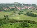
West Runton est un village du comté de Norfolk en Angleterre. Il se trouve à environ 4 kilomètres à l'est de Sheringham, et à proximité des côtes. Il y a 1633 habitants selon le recensement de 2001.
Wikimedia Foundation.
2010.
Contenu soumis à la licence CC-BY-SA. Source : Article West Runton de Wikipédia en français (auteurs)
Regardez d'autres dictionnaires:
West Runton — Infobox UK place official name= West Runton country= England region= East of England shire district= North Norfolk shire county= Norfolk civil parish= Runton static static image caption = West Runton from Incleborough Hill. With Beeston Bump in… … Wikipedia
West Runton elephant — Geobox|Prehistoric name = West Runton Elephant category = Fossilized remains image caption = Steppe mammoth official name = Mammuthus trogontherii symbol = country = United Kingdom County = Norfolk Region = East of England District = North… … Wikipedia
West Runton railway station — Infobox UK station name = West Runton manager = National Express East Anglia locale = West Runton borough = North Norfolk lowusage0405 = 16,451 lowusage0506 = 15,304 platforms = 1 start = West Runton railway station is a railway station in the… … Wikipedia
West Kingsdown Windmill — West Kingsdown Post Mill The windmills in 1906 Origin Mill name Old Mill Year built … Wikipedia
East Runton — Infobox UK place official name= East Runton country= England region= East of England shire district= North Norfolk shire county= Norfolk civil parish= Runton static static image caption = East Runton village sign population= 1,633 combined with… … Wikipedia
Meeten's Mill, West Chiltington — West Chiltington Windmill The mill in 2006 Origin Mill name Meeten s Mill Mill location … Wikipedia
BBC Radio Norfolk — Infobox Radio Station name = BBC Radio Norfolk city = Norwich area = flagicon|United Kingdom Norfolk airdate = September 11 1980 frequency = 95.1 MHz FM (East Norfolk) 95.6 MHz FM (North Norfolk) 104.4 MHz FM (West Norfolk) 855 kHz AM (East… … Wikipedia
Railway stations in Cromer — The fishing port and holiday resort of Cromer in the English county of Norfolk has had a rail service since 1877. It was served by three railway stations for many years, and is now served by two. Cromer Beach station, which opened in 1887, was… … Wikipedia
James Leak — was a Bare Knuckle prize fighter who was born in the county of Norfolk in the United Kingdom.James Leak was a resident of East Runton, Norfolk around the early part of the 1800’s. Leak was the local blacksmith and renowned Bare Knuckle prize… … Wikipedia
Iron Maiden Tour — Paul Di Anno and Steve Harris performing at the Manchester Apollo Tour by Iron Maiden Associated album … Wikipedia

 Angleterre
