Waskemeer
Contenu soumis à la licence CC-BY-SA. Source : Article Waskemeer de Wikipédia en français (auteurs)
Regardez d'autres dictionnaires:
Waskemeer — Infobox Settlement official name = Waskemeer mapsize = 280px subdivision type = Country subdivision name = flagicon|Netherlands Netherlands subdivision type1 = Province subdivision name1 = flagicon|Friesland Friesland settlement type = Village… … Wikipedia
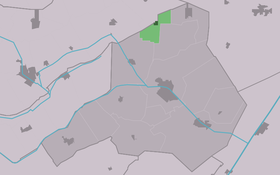
Haulerwijk-Beneden — Waskemeer Waskemeer Vue de la localité sur la carte des Pays Bas Pays … Wikipédia en Français
Ravenswoud — Infobox Settlement official name = Ravenswoud mapsize = 280px subdivision type = Country subdivision name = flagicon|Netherlands Netherlands subdivision type1 = Province subdivision name1 = flagicon|Friesland Friesland settlement type = Village… … Wikipedia
Ooststellingwerf — Municipality Flag … Wikipedia
List of places in the Netherlands — This is an alphabetical list of places (cities, towns, villages) in the Netherlands. Lists per province can be found at:* List of towns in Groningen * List of towns in Friesland * List of towns in Drente * List of towns in Overijssel * List of… … Wikipedia
Oosterwolde — Gemeinde Ooststellingwerf Flagge Wappen Provinz … Deutsch Wikipedia
Ooststellingwerf — Gemeinde Ooststellingwerf Flagge Wappen Provinz Friesland … Deutsch Wikipedia
Appelscha — 52° 57′ 17″ N 6° 21′ 00″ E / 52.9547, 6.35 … Wikipédia en Français
Donkerbroek — 53°1′1″N 6°14′9″E / 53.01694, 6.23583 … Wikipédia en Français
Elsloo (Frise) — 52°56′34″N 6°14′15″E / 52.94278, 6.2375 … Wikipédia en Français
 Pays-Bas