Verin Getashen
- Verin Getashen
-
40° 07′ 58″ N 45° 14′ 55″ E / 40.132778, 45.248611
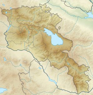
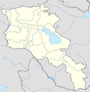
Verin Getashen (en arménien Վերին Գետաշեն) est une communauté rurale du marz de Gegharkunik, en Arménie. Fondée en 1828-1829[2], elle compte 5 031 habitants en 2008[3].
Notes et références
- ↑ (hy+en) Central Electoral Commission of the Republic of Armenia. Consulté le 24 janvier 2011.
Pour obtenir la page en anglais, cliquez sur le drapeau arménien en haut à gauche, et sélectionnez « English » ; ensuite, dans le menu vertical de gauche, cliquez sur « Local », sélectionnez le
marz pertinent, puis la dernière élection correspondant à la communauté voulue.
- ↑ (en) Brady Kiesling, Rediscovering Armenia, 2000, p. 45 [lire en ligne (page consultée le 25 mars 2010)] .
- ↑ (en) ArmStat, Marzes of the Republic of Armenia in figures, 2008, « RA Gegharkunik Marz », 2008. Consulté le 6 avril 2009.
Wikimedia Foundation.
2010.
Contenu soumis à la licence CC-BY-SA. Source : Article Verin Getashen de Wikipédia en français (auteurs)
Regardez d'autres dictionnaires:
Verin Getashen — Original name in latin Verin Getashen Name in other language Nerkin Getashen, Verin Adyaman, Verin Getashen, Verkhniy Adyaman, Неркин Геташен State code AM Continent/City Asia/Yerevan longitude 40.13328 latitude 45.25068 altitude 1976 Population… … Cities with a population over 1000 database
Verin Getashen — Infobox Settlement official name =Verin Getashen Վերին Գետաշեն native name = pushpin mapsize =150px subdivision type = Country subdivision name = Armenia subdivision type1 = Marz (Province) subdivision name1 =Gegharkunik leader title = leader… … Wikipedia
Getashen — or Getachen may refer to: *Getashen, Armavir, Armenia *Getazat, Armenia *Kirants, Armenia *Nerkin Getashen, Armenia *Verin Getashen, Armenia *Çaykənd, Goygol, Azerbaijan *Çaykənd, Shaki, Azerbaijan … Wikipedia
Verin Shorzha — 40° 05′ 48″ N 45° 48′ 01″ E / 40.096667, 45.800278 … Wikipédia en Français
Nerkin Getashen — Coordinates: 40°08′45″N 45°15′50″E / 40.14583°N 45.26389°E / 40.14583; 45.26389 … Wikipedia
Nerkin Getashen — 40° 08′ 45″ N 45° 15′ 50″ E / 40.145833, 45.263889 … Wikipédia en Français
List of municipalities of Armenia — Map of Armenia The Municipalities of Armenia are referred to as communities (համայնքներ hamaynkner, singular համայնք hamaynk ). Each community is self governing and consists of one or more settlements (bnakavayrer, singular bnakavayr).… … Wikipedia
Nerkin Shorzha — Coordinates: 40°06′36″N 45°50′10″E / 40.11°N 45.83611°E / 40.11; 45.83611 … Wikipedia
Akhpradzor — 40° 06′ N 45° 39′ E / 40.1, 45.65 … Wikipédia en Français
Geghhovit — 40° 06′ 16″ N 45° 17′ 23″ E / 40.104444, 45.289722 … Wikipédia en Français
 Arménie