Stanovoy
- Stanovoy
-
Monts Stanovoï
| Monts Stanovoï |
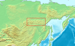
Carte de localisation des monts Stanovoï.
|
| Géographie |
| Altitude |
2 482 m, Mont Skalisty |
| Massif |
|
| Longueur |
720 km |
| Largeur |
km |
| Superficie |
km2 |
| Coordonnées |
|
| Administration |
| Pays |
 Russie Russie |
| ' |
|
| ' |
|
| Géologie |
| Âge |
|
| Roches |
|
modifier  |
Les monts Stanovoï (en russe : Станово́й хребе́т) sont une chaîne de montagnes située dans le sud de la Sibérie et la partie orientale de la Russie.
Les monts Stanovoï s'étendent sur une longueur de 720 km entre le lac Baïkal et la mer d'Okhotsk, suivant une direction générale est-ouest. Ils séparent le bassin de la Lena au nord du bassin de l'Amour au sud.
Le point culminant est le mont Skalisty (2 482 m), situé au milieu de la chaîne. Les nombreux glaciers des monts Stanovoï constituent la principale source de la Lena.
Les monts Stavonoï sont pratiquement inhabités. Ils entrèrent dans l’histoire en 1689, lorsqu'ils furent définis comme la frontière entre la Russie et la Chine par le traité de Nertchinsk
 Portail de la Russie
 Portail de la montagne
Catégories : Montagne de Russie | Massif de montagne d'Asie
Wikimedia Foundation.
2010.
Contenu soumis à la licence CC-BY-SA. Source : Article Stanovoy de Wikipédia en français (auteurs)
Regardez d'autres dictionnaires:
Stanovoy Range — (Russian: Становой хребет, Chinese: 外兴安岭), or Outer Khingan Range is a mountain range located in southeastern parts of the Russian Far East. It runs generally east west from the Olyokma River almost to the Sea of Okhotsk. It separates the… … Wikipedia
Stanovoy Range — ▪ mountains, Russia also spelled Stanovoj , Russian Stanovoy Khrebet mountain range along the boundary between Amur oblast (province) and Sakha, Russia. It trends east to west, linking the mountains of Transbaikalia to the Dzhugdzhur… … Universalium
Stanovoy — geographical name mountain range SE Russia in Asia N of the Amur … New Collegiate Dictionary
Stanovoy Mountains — Mountain range, eastern Russia, in Asia. It is part of the watershed between the Pacific and Arctic oceans. The mountains are generally not high, although they reach about 8,000 ft (2,400 m) in the east. They contain deposits of gold, coal, and… … Universalium
Asia — /ay zheuh, ay sheuh/, n. a continent bounded by Europe and the Arctic, Pacific, and Indian oceans. 2,896,700,000; ab. 16,000,000 sq. mi. (41,440,000 sq. km). * * * I Largest continent on Earth. It is bounded by the Arctic Ocean, the Pacific Ocean … Universalium
Russian–Manchu border conflicts — Russian Manchu border conflicts Qing Empire forces storming the fort of Albazin Date 1652 1689 … Wikipedia
Treaty of Nerchinsk — The Amur basin. Nerchinsk is part way up the Shilka. The Stanovoy Mountains are along the northern edge of the Amur basin. The Treaty of Nerchinsk of 1689 (Russian: Нерчинский договор; Chinese: 尼布楚條約; pinyin: Níbùchǔ Tiáoyuē) was the first treaty … Wikipedia
Russia — /rush euh/, n. 1. Also called Russian Empire. Russian, Rossiya. a former empire in E Europe and N and W Asia: overthrown by the Russian Revolution 1917. Cap.: St. Petersburg (1703 1917). 2. See Union of Soviet Socialist Republics. 3. See Russian… … Universalium
Geography of Russia — The Russian Federation stretches across much of the north of the super continent of Eurasia. Because of its size, Russia displays both monotony and diversity. As with its topography, its climates, vegetation, and soils span vast distances.cite… … Wikipedia
Amur Oblast — Infobox Russian federal subject EnglishName=Amur Oblast RussianName=Амурская область Locator LocatorMap CoatOfArmsLink=Coat of arms of Amur Oblast FlagLink=Flag of Amur Oblast AnthemLink= none AdmCtrOrCapital=Administrative center… … Wikipedia
