South Kingstown (Rhode Island)

South Kingstown (Rhode Island)
Page d'aide sur l'homonymie Pour les articles homonymes, voir Kingstown (homonymie).

41° 26′ 51″ N 71° 31′ 38″ W / 41.447500, -71.527222

South Kingstown
Administration
Pays Drapeau des États-Unis États-Unis
État Rhode Island Rhode Island
Comté Washington
Maire Mary S. Eddy
Code FIPS 44-67460
GNIS 1220090
Site web Consulter
Historique
Fondation 1722
Démographie
Population (2000) 27 921 hab.
Densité 135 hab./km²
Géographie
Coordonnées 41° 26′ 51″ Nord
       71° 31′ 38″ Ouest
/ 41.447500, -71.527222
Altitude 30 m
Superficie totale 206,6 km2
· dont terre 147,9 km2 (71,59 %)
· dont eau 58,7 km2 (28,41 %)
Fuseau horaire EST (UTC-5)
Voir la carte administrative
City locator 14.svg
Voir la carte topographique
City locator 14.svg

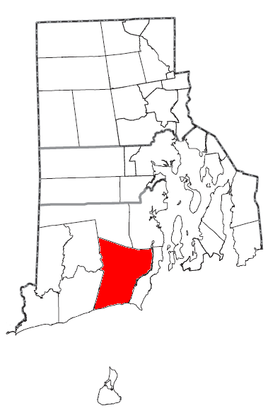
South Kingstown est une ville américaine située dans le comté de Washington, dans l’État du Rhode Island. Lors du recensement de 2000, sa population s’élevait à 27 921 habitants, ce qui en fait la ville la plus peuplée du comté (les comtés du Rhode Island n’ont pas de siège). Densité : 188,8 hab./km² (489 hab./mi²). Superficie totale : 206,6 km² (79,8 mi²). Coordonnées géographiques : 41°26′51″N 71°31′38″O / 41.4475, -71.52722.

South Kingstown recèle en son sein le village de Kingston.

Source


Wikimedia Foundation. 2010.

Contenu soumis à la licence CC-BY-SA. Source : Article South Kingstown (Rhode Island) de Wikipédia en français (auteurs)

Игры ⚽ Поможем сделать НИР

Regardez d'autres dictionnaires:

  • South Kingstown, Rhode Island — Infobox Settlement official name = South Kingstown, Rhode Island settlement type = Town nickname = motto = imagesize = image caption = image mapsize = 250px map caption = Location of South Kingstown in Rhode Island mapsize1 = map caption1 =… …   Wikipedia

  • Red House (South Kingstown, Rhode Island) — Infobox nrhp | name =Red House nrhp type = caption = location= South Kingstown, Rhode Island lat degrees = 41 lat minutes = 24 lat seconds = 2 lat direction = N long degrees = 71 long minutes = 34 long seconds = 15 long direction = W locmapin =… …   Wikipedia

  • South County (Rhode Island) — Verwaltung US Bundesstaat: Rhode Island Verwaltungssitz: West Kingston Adresse des Verwaltungssitzes: Gründung: 1729 …   Deutsch Wikipedia

  • North Kingstown, Rhode Island —   Town   The Gilbert Stuart Birthplace in North Kingstown …   Wikipedia

  • South Kingstown — South Kingstown …   Deutsch Wikipedia

  • South Kingstown — Pueblo de los Estados Unidos …   Wikipedia Español

  • Peace Dale, Rhode Island — Peace Dale Historic District U.S. National Register of Historic Places U.S. Historic district …   Wikipedia

  • Wakefield-Peacedale, Rhode Island — Infobox Settlement official name = Wakefield Peace Dale, Rhode Island settlement type = CDP nickname = motto = imagesize = image caption = image mapsize = map caption = mapsize1 = map caption1 = subdivision type = Country subdivision name =… …   Wikipedia

  • University of Rhode Island — Motto Think Big. We Do. Established 1892 Type Public Endowment $73 mil …   Wikipedia

  • Rhode Island Route 4 — Route 4 Colonel Rodman Highway …   Wikipedia

Share the article and excerpts

Direct link
Do a right-click on the link above
and select “Copy Link”