- Solway Firth
-
 Pour les articles homonymes, voir Firth.
Solway Firth 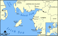
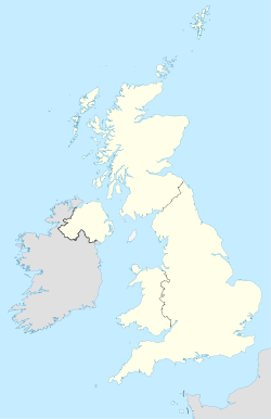
Carte du Solway Firth.Géographie humaine Pays côtier(s)  Royaume-Uni
Subdivision(s)
territoriale(s)Écosse, Angleterre Géographie physique Type Firth Localisation Mer d'Irlande (océan Atlantique) Coordonnées Géolocalisation sur la carte : Royaume-Uni

modifier 
Le Solway Firth est un firth du Royaume-Uni constituant la frontière entre l'Angleterre et l'Écosse, entre les comtés de Cumbria et de Dumfries and Galloway. Il s'étire de la pointe de St. Bees qui se trouve juste au sud de Whitehaven en Cumbria, jusqu'au Mull of Galloway, à l'extrémité occidentale de Dumfries and Galloway. Le firth comprend une partie de la mer d'Irlande.
Le littoral est caractérisé par des collines de faible altitude et des petites montagnes et souvent considéré comme le littoral le plus pittoresque des îles Britanniques. C'est principalement une zone rurale, la pêche et l'agriculture jouant encore un grand rôle dans l'économie locale, bien que celui du tourisme soit grandissant. De plus, il a également été utilisé pour le tournage de films tel que The Wicker Man avec Christopher Lee qui a été tourné près de Kirkcudbright.
 Portail de l’Écosse
 Portail de l’Angleterre
 Portail du monde maritime
Catégories :- Loch d'Écosse
- Estuaire d'Angleterre


Wikimedia Foundation. 2010.