Slieve Donard
- Slieve Donard
-
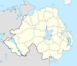
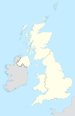
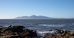
Le Slieve Donard est le sommet le plus haut de l'Irlande du Nord avec 850 mètres. Il est situé près de Newcastle, au comté de Down, à trois kilomètres de la mer. Il fait partie des montagnes de Mourne. Son nom viendrait de l' irlandais Sliabh Domengard signifiant montagne de Donard, d'après St. Donard, sympathisant de Saint Patrick et saint patron de la ville de Maghera. La montagne est facile à monter, et du sommet l'on peut voir Belfast au lointain.
Voir aussi
Wikimedia Foundation.
2010.
Contenu soumis à la licence CC-BY-SA. Source : Article Slieve Donard de Wikipédia en français (auteurs)
Regardez d'autres dictionnaires:
Slieve Donard — Die Mountains of Mourne mit dem Slieve Donard in der Bildmitte Höhe … Deutsch Wikipedia
Slieve Donard — Infobox Mountain Name=Slieve Donard Sliabh Dónairt Location = County Down, Northern Ireland Elevation=849 m (2,786 ft) Photo=mournes wiki.jpg Caption=Slieve Donard seen from St. John s Point, County Down Prominence = c. 825 m Ranked 29th in Great … Wikipedia
Slieve Donard Resort & Spa (County Down) — Slieve Donard Resort & Spa country: United Kingdom, city: County Down (Newcastle) Slieve Donard Resort & Spa Location Situated at the foot of the beautiful mountains of Mourne, the Slieve Donard Resort & Spa lies in 6 acres of private grounds… … International hotels
Slieve Donard — /sliv ˈdɒnad/ (say sleev donahd) noun the highest peak of Northern Ireland, in the south eastern part, in the Mourne Mountains. 853 m …
Donard — Not to be confused with Slieve Donard. Donard Dún Ard Town … Wikipedia
Donard Park — Coordinates: 54°12′14″N 5°54′11″W / 54.204°N 5.903°W / 54.204; 5.903 Donard Park is a public park located in Ne … Wikipedia
Slieve — (spr. ßlīw, Sliabh, Slibh), im Irischen soviel wie Berg, Gebirge. Am bekanntesten ist S. Donard (852 m) in den Mournebergen, der höchste Gipfel in Ulster … Meyers Großes Konversations-Lexikon
Mourne Mountains — Na Beanna Boirche Range … Wikipedia
Newcastle, County Down — Coordinates: 54°12′36″N 5°52′55″W / 54.21°N 5.882°W / 54.21; 5.882 … Wikipedia
Mountains of Mourne — Blick auf die Mountains of Mourne Der Mourne Wall Die Mountains of Mourne (irisch: Na Beanna Boirche) sind ein aus Granit bestehender Gebirgszug rund 50 km südlich der … Deutsch Wikipedia
 Royaume-Uni
 Irlande du Nord