Rusko Selo

Rusko Selo
Rusko Selo
Руско Село
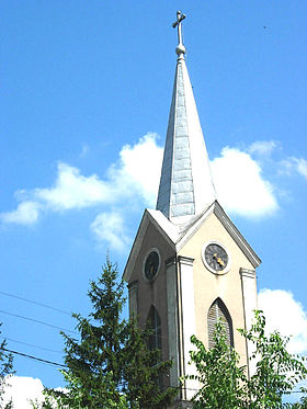
L'église catholique des Saints-Apôtres-Pierre-et-Paul à Rusko Selo
Administration
Pays Drapeau de Serbie Serbie
Province Voïvodine
Région Banat
Potisje
District Banat septentrional
Municipalité Kikinda
Code postal 23 314
Géographie
Coordonnées 45° 45′ 46″ Nord
       20° 34′ 19″ Est
/ 45.7628, 20.5719
Altitude 71 m
Superficie 2 940 ha = 29,4 km2
Démographie
Population 3 328 hab. (2002)
Densité 113,2 hab./km2
Localisation
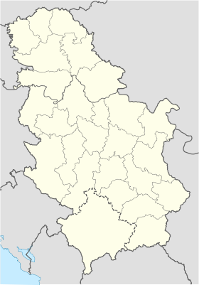
Serbia location map.svg
City locator 14.svg
Rusko Selo

Rusko Selo (en serbe cyrillique : Руско Село ; en hongrois : Torontáloroszi) est une localité de Serbie située dans la province autonome de Voïvodine. Elle fait partie de la municipalité de Kikinda dans le district du Banat septentrional. En 2002, elle comptait 3 328 habitants[1], dont une majorité de Serbes.

Rusko Selo est officiellement classé parmi les villages de Serbie.

Sommaire

Démographie

Évolution historique de la population

Évolution démographique
1948 1953 1961 1971 1981 1991 2002
4 294 4 341 4 143 3 830 3 657 3 510 3 328[1]

En 2010, la population de Rusko Selo était estimée à 3 192 habitants[2].

Répartition de la population (2002)

Nationalité Nombre %
Serbes 1 880 56,49
Hongrois 1 181 35,48
Yougoslaves 55 1,65
Roms 48 1,44
Monténégrins 43 1,29
Croates 18 0,54
Ukrainiens 12 0,36
Roumains 8 0,24
Macédoniens 3 0,09
Slovaques 2 0,06
Inconnus/Autres[3]

Notes et références

  1. a et b (sr) Livre 9, Population, analyse comparative de la population en 1948, 1953, 1961, 1971, 1981, 1991 et 2002, données par localités, Institut de statistique de la République de Serbie, Belgrade, mai 2004 (ISBN 86-84433-14-9)
  2. (fr) Rusko Selo sur http://gazetteer.de, World Gazetteer. Consulté le 21 décembre 2010
  3. (sr) Livre 1, Population, origine nationale ou ethnique, données par localités, Institut de statistique de la République de Serbie, Belgrade, février 2003 (ISBN 86-84433-00-9)

Voir aussi

Sur les autres projets Wikimedia :

Articles connexes

Liens externes


Wikimedia Foundation. 2010.

Contenu soumis à la licence CC-BY-SA. Source : Article Rusko Selo de Wikipédia en français (auteurs)

Игры ⚽ Нужно сделать НИР?

Regardez d'autres dictionnaires:

  • Rusko Selo — (Serbian: Руско Село, Hungarian: Kisorosz) is a village in the Republic of Serbia. It is situated in the Kikinda municipality, North Banat District, Autonomous Province of Vojvodina. The village has a population of 3,328 (2002 census).Historical… …   Wikipedia

  • Rusko Selo — Original name in latin Rusko Selo Name in other language Kis Orosz, Kis Oroszin, Klein Orossin, Oroszin, Rusko Selo, Ruskodorf, Torontaloroszi, Torontloroszi State code RS Continent/City Europe/Belgrade longitude 45.76291 latitude 20.57117… …   Cities with a population over 1000 database

  • Rusko Selo — Sp Rùsų Sèlas Ap Руско Село/Rusko Selo L Serbija …   Pasaulio vietovardžiai. Internetinė duomenų bazė

  • Banatsko Veliko Selo — Банатско Велико Село Maison mémoriale à Banatsko Veliko Selo Administration …   Wikipédia en Français

  • Novo Selo (Kanjiža) — Novo Selo (in Serbian: Ново Село, Hungarian: Újfalu) is a village in Serbia. It is situated in the Kanjiža municipality, in the North Banat District, Vojvodina province. The village has a Hungarian ethnic majority and its population numbering 211 …   Wikipedia

  • Kikinda — Кикинда   Municipality and Town   Kikinda City Hall …   Wikipedia

  • Kikinda — Кикинда Héraldique …   Wikipédia en Français

  • Kanjiža — Кањижа Magyarkanizsa   Municipality and Town   Catholic Church …   Wikipedia

  • List of cities, towns and villages in Serbia — This is the complete list of settlements in Serbia without Kosovo, as recorded by 2002 census, sorted by municipalities. Settlements denoted as urban (towns and cities) are marked bold. Population for every settlement is given in brackets. The… …   Wikipedia

  • List of settlements in Serbia (alphabetic) — This is the complete list of settlements in Serbia without Kosovo, as recorded by 2002 census, in alphabetic order. Settlements denoted as urban (towns and cities) are marked bold. Population for every settlement is given in brackets. The same… …   Wikipedia

Share the article and excerpts

Direct link
Do a right-click on the link above
and select “Copy Link”