Roker Park

Roker Park
Roker Park
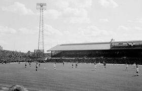
le Roker Park en août 1976
Généralités
Adresse Sunderland, Angleterre
Coordonnées 54° 55′ 17″ N 1° 22′ 32″ W / 54.9213, -1.37548154° 55′ 17″ Nord
       1° 22′ 32″ Ouest
/ 54.9213, -1.375481
  
Construction et ouverture
Construction 1897
Ouverture 10 septembre 1898
Architecte Archibald Leitch
Fermeture 1997
Démolition 1998
Utilisation
Clubs résidents Sunderland AFC (1895-1997)
Propriétaire Sunderland AFC
Équipement
Surface Pelouse naturelle
Capacité 22 500
Affluence
record
75 118 le 8 mars 1933 (FA Challenge Cup (Sunderland AFC-Derby County FC)

Géolocalisation sur la carte : Angleterre

(Voir situation sur carte : Angleterre)
Roker Park

Géolocalisation sur la carte : Tyne and Wear

(Voir situation sur carte : Tyne and Wear)
Roker Park

Roker Park était un stade de football localisé à Sunderland, en Angleterre. C'était l'enceinte du club de Sunderland AFC entre 1898 et 1997.

Ce stade de 38 000 places fut inauguré le 10 septembre 1898 par un match de championnat Sunderland AFC-Liverpool Football Club devant plus de 30 000 spectateurs. Le record d'affluence est de 75 118 spectateurs le 8 mars 1933 pour un match de FA Challenge Cup Sunderland AFC-Derby County FC. Le terrain avait été équipé d'un système d'éclairage pour les matchs en nocturne en décembre 1952.

Sunderland AFC évolue depuis 1997 au Stadium of Light.


Wikimedia Foundation. 2010.

Contenu soumis à la licence CC-BY-SA. Source : Article Roker Park de Wikipédia en français (auteurs)

Игры ⚽ Поможем написать курсовую

Regardez d'autres dictionnaires:

  • Roker Park — Saltar a navegación, búsqueda Roker Park Localización Sunderland, Inglaterra Detalles técnicos Superficie Pasto Dimensiones …   Wikipedia Español

  • Roker Park — Infobox Stadium stadium name = Roker Park nickname = location = Sunderland, England broke ground = opened = 1898 closed = 1997 demolished = 1997 owner = Sunderland A.F.C. operator = surface = Grass construction cost = architect = Archibald Leitch …   Wikipedia

  • Roker Park — 54.9213 1.3754805555556 Koordinaten: 54° 55′ 17″ N, 1° 22′ 32″ W Der Roker Park ist der Name des Fußballstadions, das in der Zeit zwischen 1898 und 1997 von dem englischen Verein FC Sunderland für Heimspiele genutzt… …   Deutsch Wikipedia

  • Roker (disambiguation) — Roker may refer to:*Roker, a seaside resort in North East England *Roker Park, a former football stadium in the Roker area *Roker Park (park), a municipal space in the Roker area *Al Roker, meteorologist for NBC s Today show *Mickey Roker, a jazz …   Wikipedia

  • Roker — infobox UK place country = England official name= Roker latitude= 54.923 longitude= 1.366 population = 4,600 metropolitan borough= City of Sunderland metropolitan county= Tyne and Wear region= North East England constituency westminster=… …   Wikipedia

  • Mowbray Park — The bandstand in Mowbray Park Type Municipal Location Sunderland, England …   Wikipedia

  • Villa Park — For other uses, see Villa Park (disambiguation). Villa Park View of the North and Doug Ellis stands Former names Aston Lower Grounds Location Trinity Road, B …   Wikipedia

  • St. Andrew's Church, Roker — Infobox church color = name = St. Andrews, Roker fullname = img size = img capt = landscape = denomination = Anglican diocese = parish = division = subdivision = founded date = founder = architect = Edward Schroeder Prior style = constructed date …   Wikipedia

  • St James' Park — infobox stadium stadium name = St James Park caption = St James Park East Stand fullname = St James Park nickname = SJP, St James, Gallowgate location = flagicon|England Newcastle upon Tyne, England, UK coordinates = opened = 1892 expanded = 1998 …   Wikipedia

  • Boundary Park — Ice Station Zebra Rochdale Road stand which houses Away Supporters. Full name Boundary Park Stadium Location …   Wikipedia

Share the article and excerpts

Direct link
Do a right-click on the link above
and select “Copy Link”