Rheidol
Contenu soumis à la licence CC-BY-SA. Source : Article Rheidol de Wikipédia en français (auteurs)
Regardez d'autres dictionnaires:
Rheidol — Sp Ráidolas Ap Rheidol angliškai, vališkai L u. Jungtinėje Karalystėje (Velse) … Pasaulio vietovardžiai. Internetinė duomenų bazė
Rheidol — Sp Ráidolas Ap Rheidol angliškai, vališkai L u. D. Britanijoje (Velse) … Pasaulio vietovardžiai. Internetinė duomenų bazė
Rheidol Falls railway station — is a railway station serving Rheidol Falls in Ceredigion in Mid Wales. It is an intermediate station on the preserved narrow gauge Vale of Rheidol Railway.###@@@KEYEND@@@### … Wikipedia
Rheidol Power Station — is a 56MW hydroelectric scheme, near Aberystwyth, Wales … Wikipedia
Vale of Rheidol Railway — Rheilffordd Cwm Rheidol Locale Ceredigion, Wales … Wikipedia
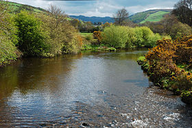
River Rheidol — The River Rheidol is a river of mid Wales. The Rheidol catchment has an area of 246 square kilometres and an average rainfall of 1760 mm of which 1272 translates into river flow. It has an average flow of 9.657 m³/s at Llanbadarn Fawr and a… … Wikipedia
Vale of Rheidol Railway locomotives — The Vale of Rheidol Railway, which runs from Aberystwyth to Devil s Bridge (Wales), opened in 1902, and was later operated by the Cambrian Railway, Great Western Railway and British Rail before being privatised in 1989 and run as a heritage… … Wikipedia
Coed Rheidol National Nature Reserve — forms part of the long ribbon of woodland around the lower slopes of hills near Devil s Bridge, Ceredigion. At the bottom of the gorge the woods take on an ancient appearance with their steep rocky slopes and gnarled trees dripping with moss. One … Wikipedia
Coedydd a Cheunant Rheidol (Rheidol Woods & Gorge) — is a Site of Special Scientific Interest in Ceredigion, west Wales. See also List of Sites of Special Scientific Interest in Ceredigion Categories: Sites of Special Scientific Interest in CeredigionUnited Kingdom Site of Special Scientific… … Wikipedia
Aberystwyth railway station — Infobox UK station name = Aberystwyth other name= code = AYW caption = Vale of Rheidol Railway s Aberystwyth station is accommodated within the former Carmarthen bay. manager = Arriva Trains Wales locale = Aberystwyth borough = Ceredigion… … Wikipedia
 Pays de Galles