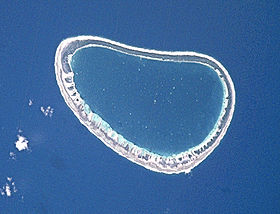
Paraoa

Paraoa
Paraoa
Photo satellite de la NASA
Géographie
Pays Drapeau de France France
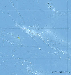
Archipel Tuamotu
Localisation Océan Pacifique
Coordonnées 19° 08′ 00″ S 140° 40′ 01″ W / -19.1333, -140.66719° 08′ 00″ S 140° 40′ 01″ W / -19.1333, -140.667
Superficie 4 km2
Géologie Atoll
Administration
Drapeau de France France
Collectivité d'outre-mer Polynésie française
District Tuamotu
Commune commune de Hao
Démographie
Population Aucun habitant
Autres informations
Découverte 1767
Fuseau horaire UTC-10

Géolocalisation sur la carte : Polynésie française

(Voir situation sur carte : Polynésie française)
Paraoa
Paraoa
Atolls de France

Paraoa également appelé Tohora ou Hariri[1], est un atoll situé dans l'archipel des Tuamotu en Polynésie française.

Géographie

Paraoa est un petit atoll ovale de 8,5 km de longueur et 5,5 km de largeur maximales pour 4 km2 de terres émergées et avec un lagon 14 km2. Il est situé à 76 km au sud d'Hao. Paraoa est administrativement rattaché à la commune de Hao.

L'atoll est inhabité.

Histoire

La première mention de l'atoll a été faite par le marin anglais Samuel Wallis en 1767[2] qui le nomma Gloucester[1].

Références

  1. a et b Names of the Paumotu Islands, with the Old Names So Far As They Are Known par J.L. Young dans The Journal of the Polynesian Society, Volume 8, No. 4, December 1899, p.264-8
  2. Tahiti et ses archipels par Pierre-Yves Toullelan, éditions Karthala, 1991, (ISBN 2-86537-291-X), p.61.

Wikimedia Foundation. 2010.

Contenu soumis à la licence CC-BY-SA. Source : Article Paraoa de Wikipédia en français (auteurs)

Игры ⚽ Нужен реферат?

Regardez d'autres dictionnaires:

  • Paraoa — Paraoa, Tohora, or Hariri is a small atoll of the central Tuamotu Archipelago in French Polynesia. It is located 76 km south of Hao Atoll s westernmost point. The closest land is Manuhangi Atoll, 52 km to the east.Paraoa Atoll is oval in shape.… …   Wikipedia

  • Paraoa — Saltar a navegación, búsqueda Localización de Paraoa en las Tuamotu Paraoa es un atolón de las Tuamotu, en la Polinesia Francesa, incluido en la comuna de Hao. Está situado a 930 km al sureste de Tahití. Sus coorden …   Wikipedia Español

  • Paraoa — Vorlage:Infobox Insel/Wartung/Höhe fehlt Paraoa NASA Bild von Paraoa Gewässer Pazifischer Ozean Archipel …   Deutsch Wikipedia

  • Tohora — Paraoa Paraoa Photo satellite de la NASA Géographie Pays …   Wikipédia en Français

  • Manuhangi — Coordinates: 19°14′S 141°15′W / 19.233°S 141.25°W / 19.233; 141.25 …   Wikipedia

  • Tuamotus — Native name: Tuamotu Flag of the Tuamotu Islands …   Wikipedia

  • Coastal fortifications of New Zealand — The New Zealand coastline is 15,134 km long. Coastal fortifications were constructed in New Zealand in two main waves. The first wave occurred around 1885 and was a response to fears of an attack by Russia. The second wave occurred during World… …   Wikipedia

  • Nengonengo — Coordinates: 18°46′S 141°48′W / 18.767°S 141.8°W / 18.767; 141.8 …   Wikipedia

  • Ahunui — Ahunui, Fanga taufa, or Nga taumanga is a small atoll of the eastern Tuamotu Archipelago in French Polynesia. It is located 55 km SSE of Paraoa Atoll and 120 km WSW of Vairaatea.Ahunui Atoll is roughly circular in shape and measures 6.5 km across …   Wikipedia

  • Amanu-Atoll — Amanu NASA Bild von Amanu Gewässer Pazifischer Ozean Archipel Anzahl der Inseln …   Deutsch Wikipedia

Share the article and excerpts

Direct link
Do a right-click on the link above
and select “Copy Link”