Oisterwijk
- Oisterwijk
-
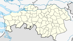
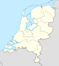
Oisterwijk est une commune et un village des Pays-Bas de la province du Brabant-Septentrional.
Localités
Géographie
- La commune d'Oisterwijk est traversée par la Reusel, qui prend le nom d'Achterste Stroom à l'est d'Oisterwijk.
Lien externe
Wikimedia Foundation.
2010.
Contenu soumis à la licence CC-BY-SA. Source : Article Oisterwijk de Wikipédia en français (auteurs)
Regardez d'autres dictionnaires:
Oisterwijk — Municipality Flag … Wikipedia
Oisterwijk — Gemeinde Oisterwijk Flagge Wappen Provinz Nordbrabant Bürg … Deutsch Wikipedia
Oisterwijk — Original name in latin Oisterwijk Name in other language Oisterwijk, Ojstervejk, Oosterwijk, Ойстервейк State code NL Continent/City Europe/Amsterdam longitude 51.57917 latitude 5.18889 altitude 13 Population 25980 Date 2010 01 29 … Cities with a population over 1000 database
Oisterwijk — Sp Òisterveikas Ap Oisterwijk L Nyderlandai … Pasaulio vietovardžiai. Internetinė duomenų bazė
Oisterwijk railway station — Oisterwijk Station statistics Coordinates 51°34′56″N … Wikipedia
Holiday home De Gerrit Hoeve Oisterwijk — (Ойстервейк,Нидерланды) Категория отеля: 1 звездочный отель Адрес … Каталог отелей
Heikant (Oisterwijk) — Heikant is a hamlet in the municipality of Oisterwijk, in the Dutch province of North Brabant. It is located about 4 km east of Moergestel. ANWB Topografische Atlas Nederland , Topografische Dienst and ANWB, 2005.] References … Wikipedia
Gemeente Oisterwijk — Admin ASC 2 Code Orig. name Gemeente Oisterwijk Country and Admin Code NL.06.0824 NL … World countries Adminstrative division ASC I-II
Adler & Oppenheimer — Schutzmarke der Adler Oppenheimer AG Adler Oppenheimer war zeitweilig der größte Konzern der europäischen Lederindustrie. Die Adler Oppenheimer Aktiengesellschaft war der gewerbliche Mittelpunkt des Konzerns und in der ersten Hälfte des 20.… … Deutsch Wikipedia
Moergestel — 51°33′0″N 5°11′0″E / 51.55, 5.18333 … Wikipédia en Français


 Pays-Bas