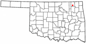
Nowata
Contenu soumis à la licence CC-BY-SA. Source : Article Nowata de Wikipédia en français (auteurs)
Regardez d'autres dictionnaires:
Nowata — Nowata, OK U.S. city in Oklahoma Population (2000): 3971 Housing Units (2000): 1853 Land area (2000): 3.101096 sq. miles (8.031802 sq. km) Water area (2000): 0.000000 sq. miles (0.000000 sq. km) Total area (2000): 3.101096 sq. miles (8.031802 sq … StarDict's U.S. Gazetteer Places
Nowata, OK — U.S. city in Oklahoma Population (2000): 3971 Housing Units (2000): 1853 Land area (2000): 3.101096 sq. miles (8.031802 sq. km) Water area (2000): 0.000000 sq. miles (0.000000 sq. km) Total area (2000): 3.101096 sq. miles (8.031802 sq. km) FIPS… … StarDict's U.S. Gazetteer Places
Nowata — Original name in latin Nowata Name in other language State code US Continent/City America/Chicago longitude 36.70064 latitude 95.63803 altitude 218 Population 3731 Date 2011 05 14 … Cities with a population over 1000 database
Nowata — Sp Novotà Ap Nowata L JAV apyg. ir jos c. (Oklahoma) … Pasaulio vietovardžiai. Internetinė duomenų bazė
Nowata, Oklahoma — City Location of Nowata, Oklahoma Coordinat … Wikipedia
Nowata County, Oklahoma — Location in the state of Oklahoma … Wikipedia
Nowata (Oklahoma) — Nowata Ciudad de los Estados Unidos Ubicación en el condado de Nowata en Oklah … Wikipedia Español
Nowata County — Verwaltung US Bundesstaat: Oklahoma Verwaltungssitz: Nowata Adresse des Verwaltungssitzes: County Courthouse 229 N Maple Street Nowata, OK 74048 2654 Gründung: 16. Juli 1907 … Deutsch Wikipedia
Nowata County — Admin ASC 2 Code Orig. name Nowata County Country and Admin Code US.OK.105 US … World countries Adminstrative division ASC I-II
National Register of Historic Places listings in Nowata County, Oklahoma — Location of Nowata County in Oklahoma This is a list of the National Register of Historic Places listings in Nowata County, Oklahoma. This is intended to be a complete list of the properties on the National Register of Historic Places in Nowata… … Wikipedia
 Pour le comté, voir Comté de Nowata.
 États-Unis
 Oklahoma